
National Current Conditions: January 22, 2025 - January 28, 2025
For the third week in a row, drought worsened in central Texas, the Southwest, and central/southern California (even with some much-needed precipitation). The Northwest, Missouri, Tennessee, and parts of the East degraded too.
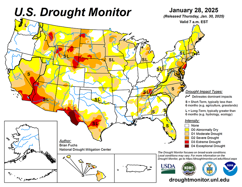
As of January 28, 2025, 33.22% of the U.S. and Puerto Rico and 39.64% of the lower 48 states are in drought, according to the U.S. Drought Monitor.
This Week's Drought Summary…
A dry week dominated the weather over much of the country with only portions of southern California and in the South along the Gulf Coast recording significant precipitation for the week. The current week started with a significant, even historical, winter storm event that impacted the coastal areas of the Gulf Coast. Several locations set all-time records for snow amounts with some locations in Louisiana having 9-10 inches of snow for the event. Some locations in the Florida panhandle also recorded 6-9 inches of snow during this event. Colder-than-normal temperatures dominated the country with the coldest readings in the Southeast, where departures were 10-15 degrees below normal, and in the northern Rocky Mountains with similar departures from normal. Portions of the northern Plains were warmer than normal, with temperatures 5-10 degrees above normal in the Dakotas and into portions of eastern Montana and western Minnesota.
Looking Ahead...
Over the next five to seven days, it is anticipated that some of the coastal areas of the Pacific Northwest could see some dryness alleviated with rains from northern California to Washington. Precipitation chances appear to be good over the northern and central Rocky Mountains. The most active rainfall pattern is expected to be from the southern Plains into the Midwest and Mid-Atlantic where some areas of Texas, Oklahoma, and Arkansas will see 2-3 inches of rain. Dry conditions will continue in the Southwest and northern Plains along with most of the Florida peninsula.
The 6-10 day outlooks show that the probability of below-normal temperatures is greatest in the Pacific Northwest and across the northern part of the United States into the High Plains. The best chances of above-normal temperatures will be over the Four-Corners region and along the southern tier of the U.S. into the Southeast and Mid-Atlantic. The greatest chances of above-normal precipitation will be over northern California into the Great Basin and the northern Rocky Mountains as well as over the Midwest. The best chances of seeing below-normal precipitation are over the Southwest and along the Gulf Coast of Florida.


