National Current Conditions: May 4, 2022 - May 10, 2022
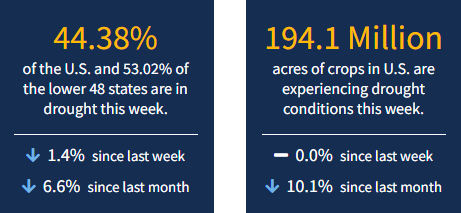
Conditions have split across the Great Plains, with western parts deteriorating and eastern parts often drought-free (see western vs. eastern Oklahoma). The Southwest continues to be dry and windy—and now heat is moving in. As of May 10, 2022, 44.38% of the U.S. and 53.02% of the lower 48 states are in drought.

This Week's Drought Summary
This U.S. Drought Monitor (USDM) week saw continued improvements on the map across the Pacific Northwest and the northern Plains in response to another round of unsettled weather during the past week. In the Pacific Northwest, Northern California, and the northern half of the Intermountain West, a series of disturbances starting last weekend brought cold temperatures and significant snowfall accumulations to the higher elevations of the Cascades, Klamath Mountains, Sierra Nevada, ranges of the northern Great Basin, and the Northern Rockies. Storm totals ranged from 6 to 18+ inches, providing a much-needed boost to mountain snowpack levels. In addition to the late-season snowfall, temperatures plummeted well below normal levels. Minimum temperatures dipped into the teens in the Sierra Nevada as well as across areas of the Intermountain West including Peter Sinks, Utah (Bear River Mountains of northern Utah), which registered the national low of 7 deg F on May 11, according to the National Weather Service Weather Prediction Center. In Northern California, recent storms and cooler temperatures helped to temporarily delay further deterioration of the already shallow snowpack, which was only 22% of normal statewide on May 11. In the Southwest, unseasonably warm, dry, and windy conditions exacerbated fire-weather conditions where nine large fires are currently impacting the region, including the Hermits Peak Fire which has scorched ~204,000 acres (43% contained) in the southern Sangre de Cristo Range, northeast of Santa Fe, New Mexico.
In the northern and central Plains, isolated showers, and thunderstorm activity led to continued modest improvements in drought-related conditions. Meanwhile, in the southern Plains and Texas, the first heat wave of the season brought 90 to 110+ deg F temperatures to the region as well as periods of critical fire-weather conditions. In eastern portions of the southern Plains, isolated heavy rainfall accumulations (3 to 8+ inches) helped to ease drought conditions. However, drought-stricken areas of western Kansas and Oklahoma largely missed out on recent storm events. In the Midwest, light to moderate rainfall accumulations (1 to 5 inches) were observed in the southern and western portion of the region this week with most of the region remaining drought-free. In the Mid-Atlantic, rainfall accumulations ranging from 2 to 4 inches across areas of Pennsylvania, Maryland, northern Virginia, and West Virginia boosted area streamflows and helped to improve drought-related conditions on the map. In the Southeast, short-term dryness during the past 30 to 90 days led to minor degradations in the Lower Savannah River Basin along the Georgia-South Carolina border, while another round of isolated storms in southern Florida led to improvements in drought-affected areas.
Looking Ahead
The NWS WPC 7-Day Quantitative Precipitation Forecast (QPF) calls for moderate-to-heavy liquid (liquid = rain + SWE) precipitation accumulations ranging from 2 to 5+ inches across western portions of Oregon and Washington while lighter accumulations (< 1 inch) are forecasted for areas of the Northern Rockies. The remainder of the West is expected to be dry during the next 7-day period. In northern portions of the High Plains, light to moderate accumulations (generally < 3 inches) are expected while light accumulations (< 1 inch) are forecasted for areas of the Midwest, South, Mid-Atlantic, and the Northeast.
The CPC 6-10-day Outlooks calls for a moderate-to-high probability of above-normal temperatures across the lower two-thirds of the conterminous U.S., while below-normal temperatures are expected across the Pacific Northwest and the Upper Midwest. In terms of precipitation, below-normal precipitation is expected across Northern California, much of the Intermountain West and Southwest, South, and the Upper Great Lakes region. Conversely, above-normal precipitation is forecasted for portions of the Pacific Northwest and the northern Plains.