National Conditions: March 8, 2023 - March 14, 2023
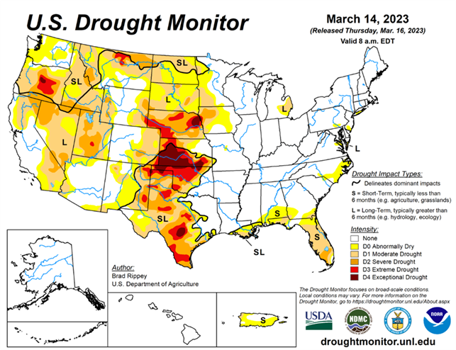
Drought continues its retreat in California as another parade of atmospheric rivers drench the state. The only areas that have been consistently worsening include parts of Texas, the South, and Florida.
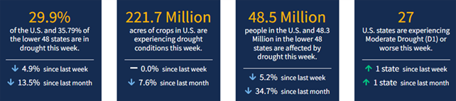
As of March 14, 2023, 29.9% of the U.S. & Puerto Rico and 35.79% of the lower 48 states are in drought, according to the U.S. Drought Monitor.
This Week's Drought Summary...
Two atmospheric river events struck California and portions of neighboring states, with the second arriving as the drought-monitoring period ended. Torrential rain in central California caused a levee break along the Pajaro River, flooding the community of Pajaro in Monterey County. Rain, along with melting of lower-elevation snowpack and dam releases, also led to significant water rises along many waterways in California’s Central Valley. By March 15, the San Joaquin River at Patterson, California, neared a record crest, with the water rising to within less than a foot of the February 2017 high-water mark. The average mid-March water equivalency of the high-elevation Sierra Nevada snowpack topped 55 inches, more than 220% normal for an entire season, according to the California Department of Water Resources. Most other areas of the West received mostly light to moderately heavy precipitation.
Farther east, storms delivered light to moderately heavy snow across the northern Plains and upper Midwest, with some of the most significant precipitation falling on March 11. Meanwhile, a band of heavy showers (locally 2 to 4 inches) stretched from northeastern Texas to the southern Appalachians, before shifting into the Deep South. Notably, northern Florida and environs received much-needed rain, following an extended period of record-setting warmth. Farther north, a powerful coastal storm developed as the monitoring period ended, battering parts of the Northeast with heavy, wet snow and high winds. Mostly dry weather covered the remainder of the country, including the central and southern High Plains, the Rio Grande Valley, and southern Florida. Elsewhere, chilly conditions dominated areas from the Pacific Coast to the northern half of the Plains, while record-setting warmth finally ended cross the Deep South. In fact, freezes were reported for several days, starting on March 14, as far south as Alabama, Georgia, and Mississippi.
Looking Ahead...
A storm system that previously hammered California with heavy precipitation and high winds will cross the central Plains on March 16 and reach the Great Lakes States a day later. A band of accumulating snow can be expected on March 16-17 from parts of Nebraska into the upper Great Lakes region. Storm-related rainfall across the South could become locally heavy, with 1 to 3 inches possible. In the storm’s wake, cold weather will return across much of the central and eastern U.S. Late in the weekend and early next week, freezes could again reach deep into the South, including parts of Mississippi, Alabama, and Georgia. Sub-0°F temperatures may occur during the weekend in portions of the north-central U.S. During the next few days, much of the West will get a reprieve from stormy conditions, although rain and snow showers will return during the weekend across the Pacific Coast States and the Southwest.
The NWS 6- to 10-day outlook for March 21–25 calls for the likelihood of near- or below-normal temperatures and near- or above-normal temperatures across most of the country. Warmer-than-normal weather will be confined to peninsular Florida and portions of the Great Lakes region, while drier-than-normal conditions should be limited to parts of the south-central U.S., mainly in Texas.