National Conditions: June 14, 2023 - June 20, 2023
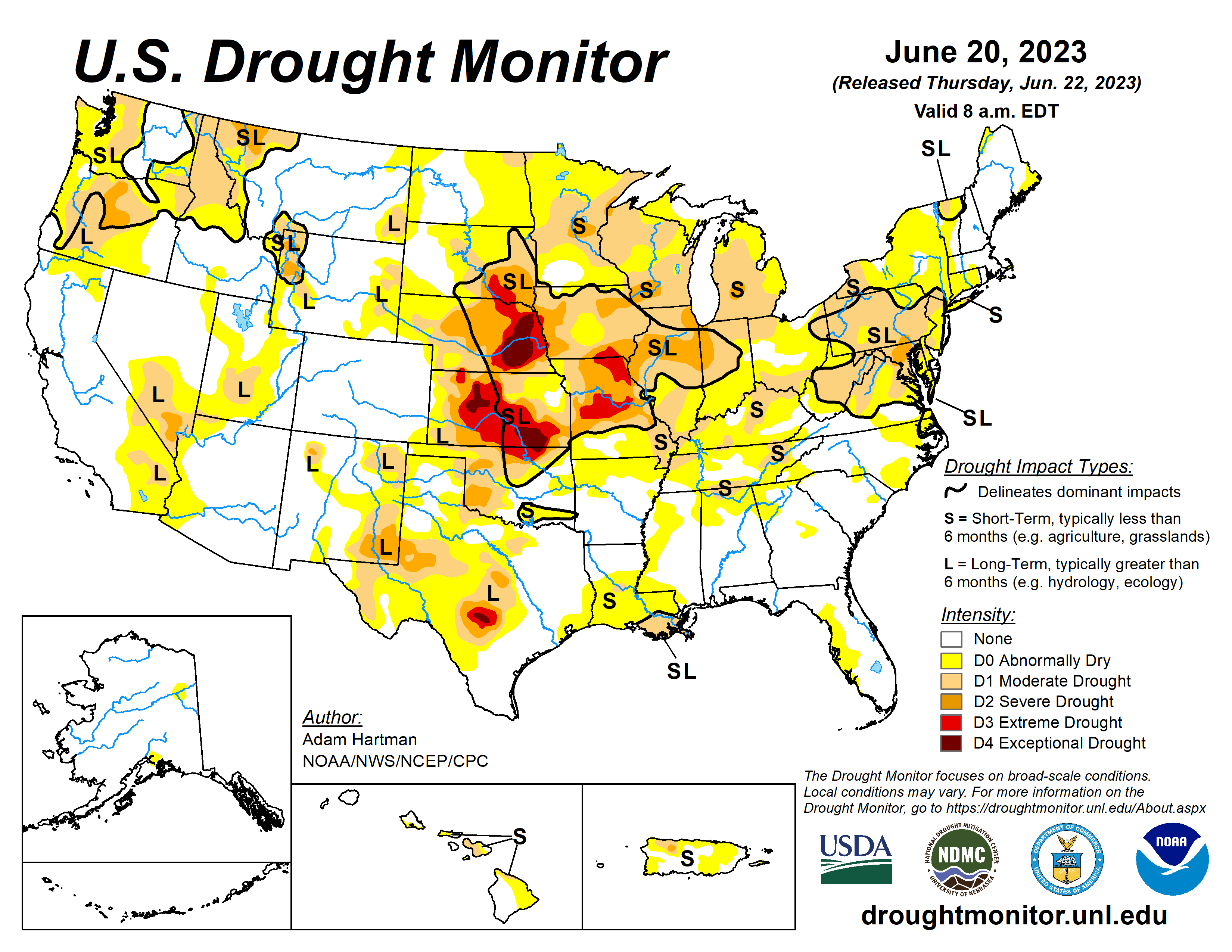
While the eastern Corn Belt received beneficial precipitation this week (especially Ohio), drought continues to rapidly intensify across most of the Midwest. The Mid-Atlantic also saw worsening conditions, with the introduction of Severe Drought (D2) in Maryland, Pennsylvania, and D.C. The good news: Heavy rainfall brought targeted drought improvements in the Intermountain West, western Southern Plains, and Florida Peninsula.
As of June 20, 2023, 22.67% of the U.S. and Puerto Rico and 27.11% of the lower 48 states are in drought, according to the U.S. Drought Monitor.


This Week's Drought Summary...
Much of the lower 48 states experienced near to below normal temperatures this week, with the exception of parts of the northern Great Plains, Upper Midwest, southern Texas, and parts of the Lower Mississippi Valley. Large portions of southern Texas experienced excessive heat this week, with daytime high temperatures averaging well above 100°F for several locations. A mean frontal boundary draped across much of the lower 48 states resulted in periods of heavy rainfall across portions of the western Great Plains and Intermountain West, leading to improvements to drought conditions across much of the western half of the lower 48 states. The only exception was in the northern Cascades in Washington, where below-normal precipitation led to worsening drought conditions.
Heavy rain also fell across parts of the Southeast, with many locations across the Deep South receiving in excess of 5 inches of rainfall, leading to improvements to abnormally dry and moderate drought conditions from central Mississippi southeastward to Florida. Toward the end of the weekend, a slow-moving storm system traversing eastward across the Middle Mississippi and Ohio Valleys resulted in additional periods of heavy rainfall across portions of the eastern U.S. However, much of the Mississippi and Ohio Valleys and the Northeast experienced a mix of worsening and improving drought conditions based on antecedent dryness and where the heaviest rain fell, respectively. Another round of deterioration was warranted again this week across much of the Midwest and eastern Great Plains, where below average precipitation continued to add to precipitation deficits that go back several months.
Looking Ahead...
Over the next 6 days (June 22 - 27) above normal temperatures are forecast to dissipate and become more seasonal across the Great Lakes and Middle and Upper Mississippi Valley, and become confined to the south-central U.S. Parts of the Southern Plains could see record heat this week, as temperatures are likely to soar well above 100°F for many locations, with the potential for some locations to exceed 110°F. Much of the remainder of the lower 48 states is likely to experience seasonal to below normal temperatures. WPC predicts above normal precipitation across portions of the Central and Northern Plains and Upper Midwest, with the potential for several areas to receive in excess of 3 inches of rainfall. Above normal rainfall is also expected across much of the Eastern U.S., associated with a lingering storm system helping to usher in moisture from the western Atlantic.
During the next 6 to 10 days (June 27 - July 1), the Climate Prediction Center (CPC) favors near to below normal temperatures across much of California and the central Great Basin. Near to below normal temperatures are also predicted across much of the northern tier states from the Northern Plains to the Great Lakes, and southeastward into the Mid-Atlantic. Above normal temperatures are favored in the Pacific Northwest and New England. Above normal temperatures are strongly favored across the south-central U.S., with the potential for record heat across portions of the Southern Plains and Lower Mississippi Valley. Near and above normal precipitation is favored across much of the lower 48 states. However, below normal precipitation is more likely across the Four Corners region, extending eastward into the Southern Plains and Lower Mississippi Valley.