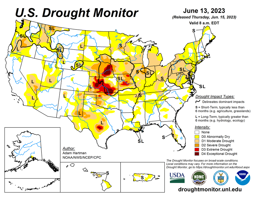
National Conditions: June 7, 2023 - June 13, 2023
This was a week of big changes... Above-normal precipitation brought improvements in much of the Western U.S. (except the Pacific Northwest), as well as the western Great Plains. However, drought worsened in the Midwest, and parts of the Pacific Northwest and Southeast also saw degradations.
As of June 13, 2023, 20.89% of the U.S. and Puerto Rico and 24.98% of the lower 48 states are in drought, according to the U.S. Drought Monitor.


This Week's Drought Summary...
Above normal precipitation and below normal temperatures resulted in another week of targeted improvements across portions of the Intermountain West, adding to recent precipitation totals that have continued to improve long-term drought conditions. The exception is the Pacific Northwest, where below normal precipitation and above normal temperatures resulted in worsening drought conditions along the northern Cascades.
There is a mix of improving and worsening drought conditions across the Great Plains. Improvements are mainly confined to the western Great Plains, where widespread 7-day rainfall totals exceeded 200 percent of average for the week, further adding to short-term precipitation surpluses. From the eastern Great Plains to the Eastern Seaboard, 7-day rainfall surpluses are more scattered in nature, leading to only modest improvements in areas seeing the heaviest amounts. In areas that received below normal rainfall this week, drought worsened, as rainfall deficits continue to increase.
Looking Ahead...
According to the Weather Prediction Center, over the next 6 days (June 15 - 20) warm temperatures are forecast to build across central portions of the lower 48 states, with cooler temperatures forecast across much of the Intermountain West and the West Coast leading up to June 20. Generally seasonal temperatures are likely east of the Mississippi River. Rainfall is forecast across a large swath of the lower 48 states from the Pacific Northwest to the Southeast, and northward along the East Coast. In the Southeast, heavy precipitation (in excess of 5 inches) is forecast for parts of the Deep South and the central and eastern Gulf Coast region.
During the next 6 to 10 days (June 20 - 24), the Climate Prediction Center favors below normal temperatures across the western third of the lower 48 states, and across parts of the Mid-Atlantic coast and Appalachians. Above normal temperatures are favored for the Great Plains, Mississippi River Valley, Great Lakes, interior Northeast, and southern Florida. Above normal precipitation is indicated across northwestern and north-central portions of the lower 48 states, and across the Southeast and Mid-Atlantic states. Below normal precipitation is weakly favored across parts of southern Texas and extending into the Four Corners region, parts of the Midwest, and northern New England.


