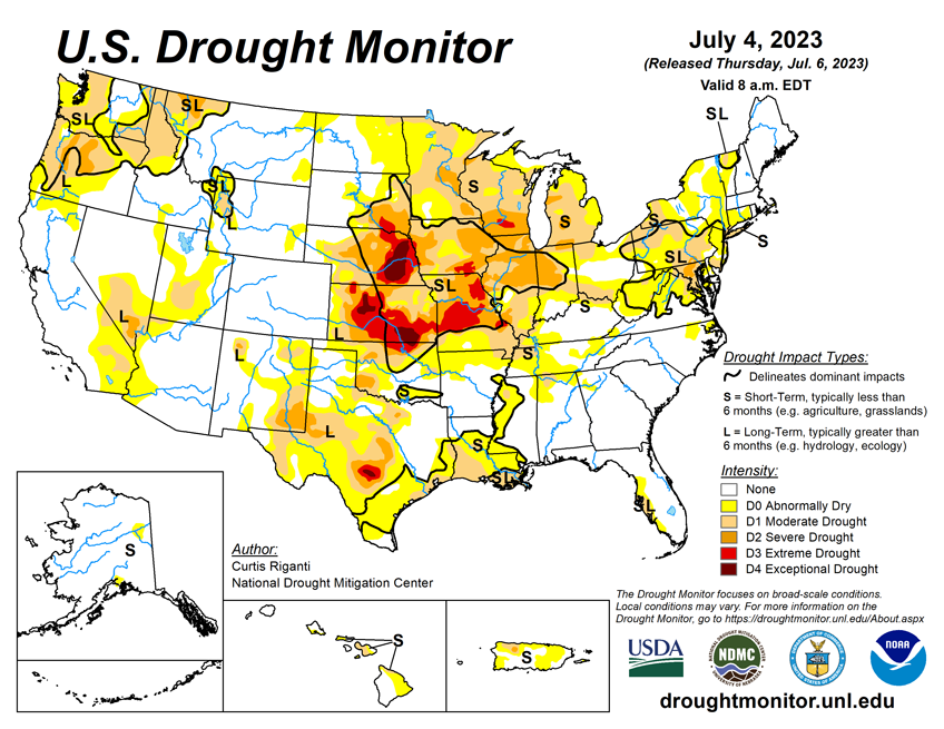
The Midwest saw drought improve and worsen as storms crossed the middle of the region. The Plains experienced hit-or-miss storms too. Elsewhere, conditions improved in the Northeast and Mid-Atlantic, and Texas and Louisiana worsened.
As of July 4, 2023, 22.57% of the U.S. and Puerto Rico and 26.95% of the lower 48 states are in drought, according to the U.S. Drought Monitor.

Change from Last Week...

This Week's Drought Summary...
Heavy rains fell this week across parts of the Midwest, Ohio River Valley and Northeast, which led to widespread improvements from southeast Nebraska to central Illinois, southern Indiana, and central and eastern Kentucky. To the south and west, in southern Missouri, the Texas-Louisiana border and other parts of central Texas, drier weather led to worsening precipitation deficits, and significant problems with hay production in parts of southern Missouri. Dry weather in the Upper Midwest led to further degrading conditions in parts of Michigan, Wisconsin and Minnesota.
A re-evaluation of conditions in parts of the western Great Plains led to some improvements to long-term dryness and long-term moderate drought in the Texas and Oklahoma Panhandle region, and in western Nebraska and eastern Wyoming, respectively. A mix of degradations and improvements occurred in the Pacific Northwest. No changes were made to the USDM depictions this week outside of the Lower 48.
Looking Ahead...
The National Weather Service forecast (valid July 5–7, 2023) calls for the latest heat wave in the Pacific Northwest to reach its peak intensity on Wednesday, July 5, with temperatures topping the lower 100s in the hottest locations. Excessive heat warnings and heat advisories coincide with many areas designated as abnormally dry or moderate drought. The heat is expected to taper off moving into the weekend. Farther south, hot, dry and windy conditions support an Excessive Heat Warning in southern Arizona and a Critical Fire Risk designation in northern Arizona, which overlaps areas of moderate drought. Showers and thunderstorms are expected to bring periods of heavy to excessive rainfall to drought-affected areas of the Central Plains and Midwest. Scattered thunderstorms are expected to linger across the southern tier of states. As a reminder, weather within this timeframe is after the data cutoff for this week and will be reflected on next week’s map. Heading into the weekend, the extended forecast (valid July 7–11, 2023) calls for hazardous heat across portions of California, the Southwest, the Southern Rockies, the South and the Southeast. This expected multi-day heat wave could worsen existing drought conditions in these regions. Showers and thunderstorms are forecast for portions of the Central Plains, Midwest and South. Whether these rains will be beneficial and help ease drought concerns in these areas remains to be seen. While thunderstorms can produce large amounts of precipitation in a very short time, most of the rain runs off into drainage channels and streams. On the other hand, rain falling as light to moderate showers soaks into the ground, helps to recharge groundwater, sustains vegetation, and begins to chip away at moisture deficits that have built up during drought.Next week, the 6- to 10-day outlook (valid July 12–18, 2023) calls for an increased probability that the observed temperature, averaged over this 7-day period, will be above normal across the Southern Plains, much of the West, the Southeast and the Northeast. South Texas and South Florida have an 80–90% chance that the average temperature will be above normal during this period. In general, the odds of a warmer-than-normal average temperature decrease moving northward. The odds that the observed temperature, averaged over the same 7-day period, will be cooler than normal are highest in the Midwest (33–50%). Below-normal precipitation probabilities are increased across parts of the Southern Plains, Nevada and the Four Corners Region. Utah has a 50–60% chance that the total precipitation over the 7-day period will be below normal. Meanwhile, the Midwest has the highest probability (40-50%) that observed precipitation totals will be above normal. Other areas with an increased probability of above-normal precipitation include parts of the Pacific Northwest, northern Plains, Midwest and Northeast.