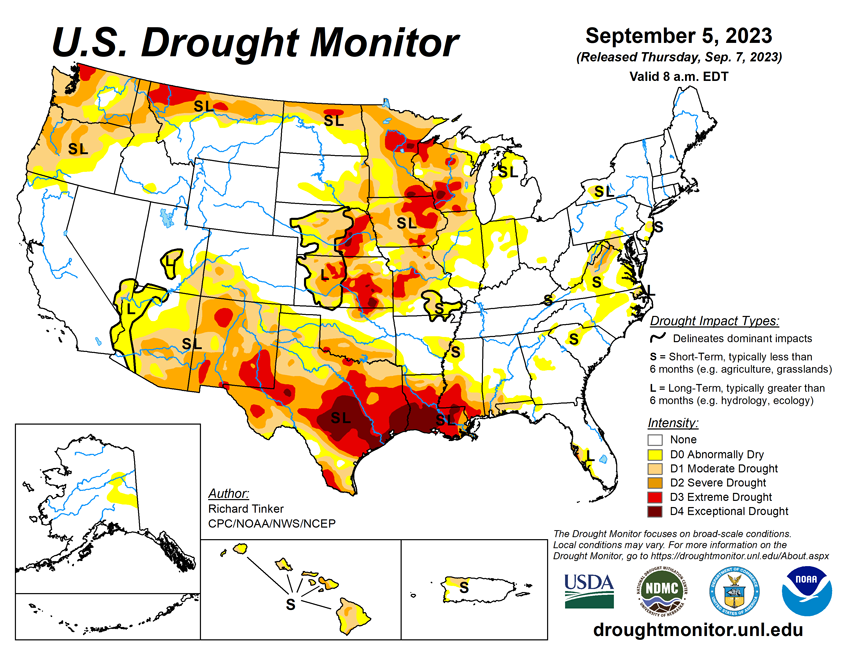
National Current Conditions: August 30, 2023 - September 5, 2023
Heat and dryness dominated large parts of the U.S. this past week, worsening drought in the Northwest, Plains, Midwest, and from eastern Arizona across to Louisiana and Mississippi. Nationwide drought coverage rose for the 8th straight week.
As of September 5, 2023, 30.20% of the U.S. and Puerto Rico and 36.02% of the lower 48 states are in drought, according to the U.S. Drought Monitor.


This Week's Drought Summary...
Heavy rainfall associated with Hurricane Idalia brought damaging winds and flooding centered along its path. Idalia moved from the Gulf of Mexico inland along the northeastern Gulf Coast of Florida and continued northeastward through south-central and east-central Georgia, slightly inland from the South Carolina Coast, then across southeastern North Carolina before moving into the open waters of the northwestern Atlantic Ocean. A solid swath of heavy rains were observed in a band from the eastern Florida Panhandle northward through middle Georgia, interior eastern South Carolina, and southeastern North Carolina as far north as the lower Outer Banks. Between 4.5 to 10.0 inches of rain fell solidly along this swath of land, but rainfall totals dropped off rapidly to the west and east of the main band.
Farther west, a surge of tropical moisture pushed northward into the southwestern U.S., continuing northward across the Great Basin, Intermountain West, and adjacent Rockies into adjacent Canada. Heavy rainfall fell in a broken pattern over this general area, with the highest amounts reported across interior southeastern California, over much of the middle Colorado River Basin, and across scattered areas farther north. The heaviest amounts outside the lower Colorado River Basin fell on higher elevations and over areas where precipitation was enhanced by orography, as is typical.
Most of the Nation, however, endured a hot and drier-than-normal week, including most areas of drought. Temperatures averaged 5 to 10 deg. F accompanied deficient precipitation over a large area from the Rockies to the Appalachians and central Gulf Coast Region, prompting drought intensification over large parts of the Upper Mississippi Valley, the Central States, and the southern tier of the country west of the Florida Panhandle. Improvement was limited to the band of heavy precipitation from Hurricane Idalia, and in scattered locales affected by the tropical moisture surge in the Desert Southwest, from southeastern Utah to central Arizona westward toward central California. According to the U.S. Department of Agriculture (USDA), the coverage of topsoils short or very short of moisture increased by 6 percent this past week, now covering 58 percent of the contiguous 48 states. This is the greatest coverage at this time of year in more than 9 years, the prior record in that short interim being just over 50 percent in 2020.
Looking Ahead...
The next 5 days (September 7-11, 2023) will bring some much-needed rainfall to the parched central Plains. Over 0.5 inch is forecast from parts of Oklahoma and the Texas Panhandle northward through Nebraska, with 1.5 to locally 3.0 inches anticipated in part of central Kansas. Moderate to heavy precipitation is also anticipated from the southern Appalachians and adjacent foothills northeastward through the mid-Atlantic and Northeast. At least 1.5 inches is expected from the mountains of northwestern Virginia northeastward through most of the Northeast and New England. The heaviest amounts are expected from central Pennsylvania northeastward through interior southeastern New York, where totals could top 4 inches. Eastern Florida could also receive moderate to locally heavy precipitation, generally 0.5 to locally 2.0 inches. A broad area covering most of the Plains and the Lower Mississippi Valley are expecting several tenths of an inch of precipitation, as are most locations from the Appalachians and eastern Gulf Coast Region eastward to the Atlantic Seaboard. Most other places might see light precipitation, but little or none is expected across the Far West, most of the Rockies, southern Texas, the southern High Plains, the Middle Mississippi and Lower Ohio Valleys, And parts of the interior Deep South. Hot weather is expected to accompany subnormal rainfall totals along the southern tier of the country from southernmost California eastward through the central Gulf Coast Region, as has been the case much of the summer. Daily maximum temperatures are expected to average 5 to 9 deg. F above normal there. In contrast, milder than normal temperatures are expected to displace the heat that has recently affected parts of the Nation’s Midsection, with readings expected to average 3 to 7 deg. F below normal across much of the region from the central High Plains eastward across the Middle Mississippi and Ohio Valleys.The 6-10 day outlook (valid September 12-16, 2023) favors a similar pattern. Odds favor above-normal temperatures from the South Atlantic Region westward across the southern tier of the Contiguous 48 states, over most areas from the Rockies westward, and the northern Plains. Meanwhile, below-normal temperatures are favored across a large swath from the south-central Plains eastward through most of the Mississippi Valley, the Upper Southeast, the Appalachians, the Atlantic Piedmont, the Mid-Atlantic, and the lower Northeast. There are enhanced chances for surplus precipitation across the central and southern Rockies, much of the central and southern Plains, the southern half of the Mississippi Valley, the Ohio Valley, the interior Southeast, the Appalachians, the mid-Atlantic, and the Northeast. In contrast, drier-than-normal weather is favored across most of the Great Lakes, the northern tiers of the Plains and Rockies, the northern Intermountain West, and the Pacific Northwest, as well as across the Florida Peninsula.