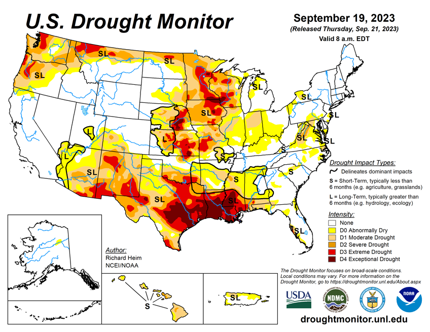
National Current Conditions: September 13, 2023 - September 19, 2023
Drought worsened in parts of the Upper Midwest and Central Plains, but helpful rains are coming. This past week, precipitation brought improvements to much of western and central Texas. However, eastern Texas into Louisiana and Mississippi saw an expansion of Exceptional Drought (D4).
As of September 19, 2023, 31.71% of the U.S. and Puerto Rico and 37.78% of the lower 48 states are in drought, according to the U.S. Drought Monitor.


This Week's Drought Summary...
Several Pacific weather systems moved through the jet-stream flow during this U.S. Drought Monitor (USDM) week (September 13-19). The upper-level circulation still consisted of an upper-level ridge over the western contiguous U.S. (CONUS), but it was weakened by the traversing Pacific weather systems. The ridge kept most of the western U.S. dry with warmer-than-normal temperatures from northern California to Montana. Cold fronts and surface low-pressure systems, that accompanied the weather systems, brought rain to the Southwest, southern Plains, Southeast, and Northeast. Heavy rain fell across western to central Texas, improving drought conditions. The rain in the East fell mostly on non-drought areas. The fronts kept temperatures cooler than normal from the Southwest to most of the southern Plains and across much of the country from the Mississippi River to East Coast – only the Gulf of Mexico coast and New England had a warmer-than-normal week.
In addition to getting rain from frontal systems, parts of New England were soaked by the remnants of Hurricane Lee over the weekend. The northern Plains and parts of the central Plains, the Great Lakes, and the Mississippi and Ohio Valleys had a drier-than-normal week. The dryness this week was a continuation of dry conditions that have lasted for several months – in some cases for years – across parts of the country and that have dried out soils across more than half of the CONUS. According to U.S. Department of Agriculture statistics, 58% of the nation’s topsoil moisture and 59% of the subsoil moisture was dry or very dry. For topsoil moisture, based on data going back to 2015, this amount is second only to the drought of 2022, which peaked at 68%. The continued dry conditions resulted in expansion or intensification of drought and abnormal dryness across parts of the Mississippi and Ohio Valleys, Mid-Atlantic states, and Pacific Northwest.
Looking Ahead...
In the two days since the valid time of this USDM, rain has fallen across parts of the West, parts of the Plains to Mississippi Valley, and parts of Florida. For September 21-26, a strong weather system will slowly move out of the Rockies into the Plains and spread heavy rain across much of the Plains to Mississippi Valley, while a low-pressure system moves along the East Coast, spreading heavy rain to coastal areas, and a third Pacific weather system brings rain to coastal areas from northern California to Washington. Weekly precipitation totals could range from 1 to locally 5 inches or more in these regions. Other parts of the Far West, the Four Corners states, much of the Southeast, and the Appalachians to eastern Great Lakes are expected to receive little to no precipitation. Temperatures are expected to be warmer than normal across parts of the Plains to the Mississippi River Valley and Great Lakes.The 6-10 Day Outlook (valid September 26-30) favors above-normal precipitation from northern California to North Dakota and across much of the Southeast, with below-normal precipitation centered over Colorado and extending from Missouri to the Great Lakes and New England. Odds favor near normal precipitation for Alaska. The outlook is for below-normal temperatures over southwest Alaska and the Far West in the CONUS, and above-normal temperatures from the Rockies to Appalachians and over northeast Alaska.
The temperature pattern favored in CPC’s 8-14 Day Outlook (valid September 28-October 4) is a continuation of that in the 6-10 Day Outlook, with cooler-than-normal temperatures extending to the Rocky Mountains and the warmer-than-normal area extending to the East Coast. The area favored for above-normal precipitation extends across the Great Plains, while the below-normal area extends to the Lower Mississippi Valley. Odds favor above-normal precipitation for most of Alaska.