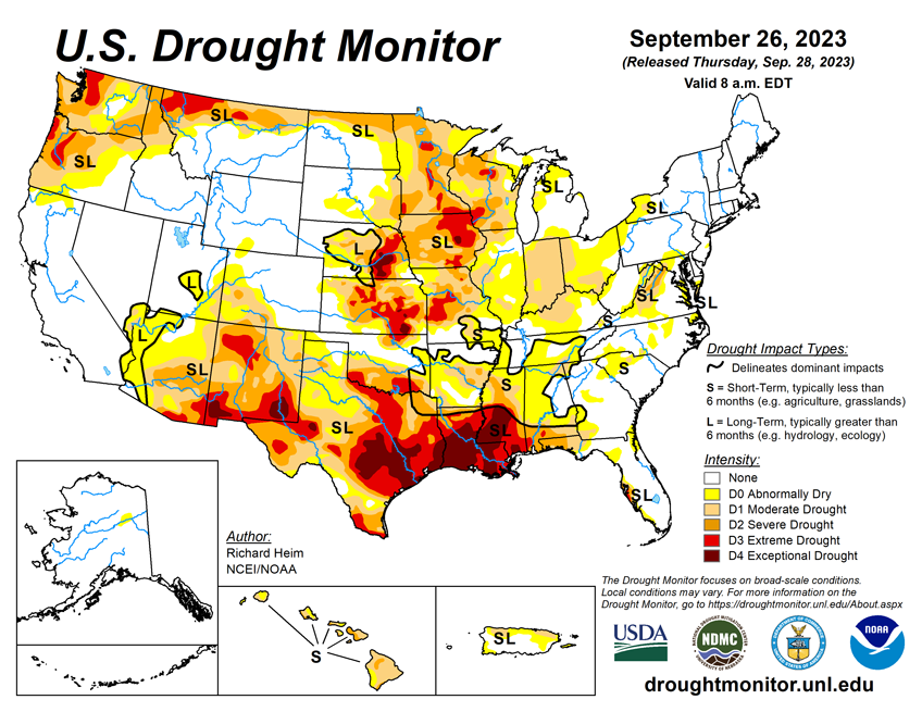
National Current Conditions: September 20, 2023 - September 26, 2023
The Plains and Upper Midwest saw improvements this past week, while drought worsened in the South and Ohio River Basin. Drought has also returned to the Southwest after record summer heat and a weak monsoon.
As of September 26, 2023, 32.10% of the U.S. and Puerto Rico and 38.23% of the lower 48 states are in drought, according to the U.S. Drought Monitor.


This Week's Drought Summary...
The upper-level circulation over the contiguous U.S. (CONUS) during this U.S. Drought Monitor (USDM) week (September 20-26) consisted of an upper-level ridge of high pressure, that extended from the southern Plains to Hudson Bay, and a low-pressure trough over the eastern Pacific. The trough sent weather systems spinning across the CONUS, with their fronts and surface low pressure systems generating areas of rain across the Pacific Northwest, northern Rockies, and Great Plains to the Mississippi Valley.
Meanwhile, Tropical Storm Ophelia moved up the East Coast, spreading rain from North Carolina to southern New England. These areas were wetter than normal for the week. Some of the rain was locally heavy, with over 5 inches reported in places. Much of the rain fell over severely dry areas, which resulted in contraction or reduction in the intensity of drought in parts of the Great Plains, Upper Mississippi Valley, and Mid-Atlantic states. It was drier than normal across the rest of the West, large parts of the central to southern Plains, and most of the country between the Mississippi Valley and Appalachians. The continued dry conditions from the Ohio Valley to central Gulf of Mexico Coast resulted in expansion or intensification of drought and abnormal dryness in these areas. Temperatures averaged warmer than normal beneath the ridge across the Plains, Mississippi Valley, and Great Lakes. The week was cooler than normal in the West and across the East Coast states.
Looking Ahead...
In the two days since the Tuesday valid time of this USDM, the atmospheric river continued in the Pacific Northwest and rain has fallen across parts of the Midwest, Texas, and Florida. For September 28-October 3, a slow-moving weather system will drop 1 to locally 2 inches of rain across the Ohio Valley and parts of the Upper Mississippi Valley, while a Pacific weather system will move across the northwestern CONUS, spreading 1 to 2 inches of precipitation across the Pacific Northwest and Montana, with heavier amounts (up to 4 inches or more expected) in coastal areas of Washington and Oregon. The Florida peninsula is forecast to get 2 to 4 inches of rain, while the Gulf Coast, Rio Grande Valley, and Mid-Atlantic states can expect an inch or less. The Southwest, New England, Carolina Piedmont, and most of New York and the southern Plains to Iowa are predicted to receive little to no precipitation. Temperatures are progged to be above normal from the Plains to Northeast and near to below normal across the Southeast and West.
For much of the next 2 weeks, the atmospheric circulation will consist of an upper-level trough over the western CONUS and a ridge over the Mississippi Valley. The trough/ridge system will slowly shift east during the period. The Climate Prediction Center’s (CPC) 6-10 Day Outlook (valid October 3-7) and 8-14 Day Outlook (valid October 5-11) favor a fairly stable pattern of warmer-than-normal temperatures from the Plains to East Coast and cooler-than-normal temperatures over the West and over the southeastern half of Alaska. The outlook is for above-normal precipitation over the Plains, Upper Mississippi Valley, northern half of the West, and most of Alaska. Odds favor below-normal precipitation over the Northeast and Appalachian Mountain chain, extending into the Ohio Valley and to the central Gulf Coast, as well as in the Alaska panhandle.