National Current Conditions: October 4, 2023 - October 10, 2023
Nationwide drought coverage decreased every so slightly for the first time after 11 weeks of increases, according to the U.S. Drought Monitor. This past week, the Northwest and the Northern and Southern Plains saw improvements, while the Southwest and Southeast experienced degradations. One month ago, 7.5% of the Southeast was in drought. Now, 27.4% is in drought.
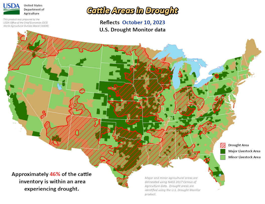
As of October 10, 2023, 33.59% of the U.S. and Puerto Rico and 40.01% of the lower 48 states are in drought, according to the U.S. Drought Monitor.


This Week's Drought Summary...
A strong cold front resulted in moderate to heavy precipitation across the Great Plains, Ozarks, and western Gulf Coast during the first week of October. The most widespread improvements were made to southern Arkansas, northwestern Louisiana, southeastern Oklahoma, and eastern to central Texas where more than 2 inches of precipitation was observed this past week. Following anomalous heat across the central U.S. to start October, the cold front ushered in much cooler temperatures from October 5 to 7. The first frost or freeze of the fall affected the Northern to Central Great Plains on October 7. As the cold front progressed eastward, drought-easing rainfall overspread parts of Illinois, northern Indiana, southern Michigan, and western New York. Father to the south, short-term drought continued to expand north and east across the Southeast. Following a wet September, minor improvements were warranted for parts of Washington. Heavy rainfall, associated with Tropical Storm Philippe, resulted in improving drought for eastern Puerto Rico. Drought continues to intensify across parts of Maui and the Big Island.
Looking Ahead...
During the next five days (October 12-16, 2023), an intense low pressure system is forecast to track from the Central Rockies and Great Plains eastward to the Midwest and Central Appalachians. A swath of heavy precipitation (1 to 3 inches) is likely to accompany this surface low. On October 12th, a vigorous area of mid-level low pressure is expected to bring heavy snow (6 to 12 inches) to the higher elevations of Wyoming. A low pressure system is forecast to move offshore of the Southeast by October 13th after it brings widespread precipitation to parts of the Southeast. Mostly dry weather is forecast to persist across the Tennessee Valley, while much drier weather prevails across the Southern Great Plains. Periods of light to moderate precipitation are expected for the coastal Pacific Northwest.
The 6-10 day outlook (valid October 17-21, 2023) favors near to below-normal precipitation throughout much of the contiguous U.S. with above-normal precipitation most likely across southeastern Alaska. Increased probabilities for above-normal temperatures are forecast across the West and Northern to Central Great Plains, while below-normal temperatures are likely for the Mid-Atlantic and Southeast.


