National Current Conditions: December 20, 2023 - December 26, 2023
Storms improved drought in much of the South Central U.S. and along the Missouri/Kansas border. Meanwhile, drought expanded in central and southwestern Texas. Snow drought is also creeping into the Northern Rockies.
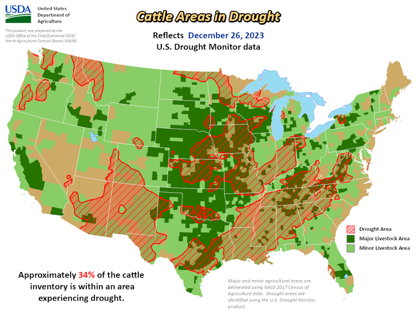
As of December 26, 2023, 27.07% of the U.S. and Puerto Rico and 32.35% of the lower 48 states are in drought, according to the U.S. Drought Monitor.


This Week's Drought Summary…
A low pressure system developed over the central Plains in conjunction with an amplifying upper-level trough dipping into the northern Plains brought active weather across much of the central to eastern U.S. Warm and moist air from the Gulf of Mexico moved northward ahead of the developing low pressure, producing widespread moderate to heavy rainfall from Texas to Louisiana. Meanwhile, a cold air mass from Canada dipped into the northern portions of the U.S. brought blizzard conditions to portions of the Central Plains and Upper Midwest. Temperatures were above-normal across most of the U.S., by as much as 20+ degrees F above average in parts of the Upper Midwest and Northern Plains.
The most widespread improvements were made to parts of central Texas, eastern Nebraska, eastern Kansas, southern Louisiana and from northern Alabama to western North Carolina, where above-normal precipitation was observed this past week. Dry conditions continued across the eastern portions of the Southern region, with degradations occurring across much of Mississippi and into Arkansas and Tennessee. Drought and abnormal dryness were also expanded or intensified in portions of the northern Rockies and in parts southern Illinois, southern Texas and in the Southeast. In Hawaii, heavy rainfall improved conditions over parts of Kauai, Oahu and the Big Island, while no changes occurred on Molokai, Lanai or Maui.
Looking Ahead...
During the next five days (December 26-30, 2023), an initial Plains/Midwest upper low will work to establish the eastern upper trough, and an associated surface system will spread rainfall of varying intensity over the East early-mid week along with the potential for lingering snow over the north-central Plains. Over the West, most precipitation should focus near the West Coast with a couple frontal systems tending to produce the highest totals over/near northern California. In terms of temperatures, expect unseasonably warm conditions in the East Tuesday and Wednesday ahead of the approaching frontal system. Morning lows should be particularly anomalous with readings 20-30 degrees above normal for much of the East and Upper Midwest. Warmer than normal temperatures will likely linger even longer in the Northeast through Thursday or Friday. Cooler air behind the system will initially still be on the mild side, with only slightly below normal readings over the central-southern Rockies/Plains on Tuesday. As upper troughing becomes established over the East later in the week, the Southeast and vicinity should trend cooler with temperatures dropping to 5-10 degrees or so below normal. Much of the West should see moderately above normal temperatures through the period.
The 6-10 day outlook (valid December 31, 2023 – January 4, 2024) favors above-normal precipitation from California to Alabama, and across much of Alaska, with below-normal precipitation most likely from the northern Plains to the Northeast, in portions of the Northwest and Hawaii, and in parts of southern Florida and Alaska Panhandle. Increased probabilities for below-normal temperatures are forecast for much of southeastern U.S. and on the eastern islands of Hawaii, while above-normal temperatures over much of the West, along the northern tier and in parts of the southern Plains, as well as Alaska and western islands of Hawaii.