National Current Conditions: December 6, 2023 - December 12, 2023
More rain means less drought for the South/Southeast. However, southeastern Arkansas, northern Louisiana, and northern Mississippi have mostly missed out. For the Midwest, the opposite is true. A few drought improvements were surrounded by degradations.
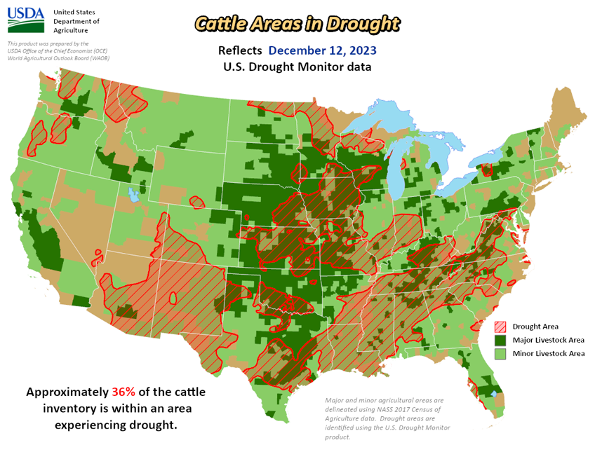
As of December 12, 2023, 28.05% of the U.S. and Puerto Rico and 33.52% of the lower 48 states are in drought, according to the U.S. Drought Monitor.


This Week's Drought Summary...
Heavy precipitation fell this week across parts of the Pacific Northwest, associated with an atmospheric river. While precipitation amounts were hefty, improvements to drought were primarily confined to lower elevation areas, given the higher snow levels with this system. Aside from parts of the Rockies in Colorado and southeast Idaho and northwest Wyoming, mainly drier weather occurred from the southwest United States through the Great Plains and Upper Midwest.
Widespread moderate to heavy rain fell with showers and thunderstorms from southeast Texas across much of the Southeast into the Mid-Atlantic and Northeast regions. Widespread improvements to drought conditions occurred with these heavier rains, though they were somewhat tempered by ongoing long-term precipitation deficits in some areas. Northwest of the heavy rains, drought and dryness expanded in some spots in Arkansas and in parts of the Upper Great Lakes and Midwest, as short-term precipitation shortfalls grew amid lowering streamflows and soil moisture. Rainfall from last week’s Kona low in Hawaii led to further improvements across parts of the state this week. For more local information, please see the regional summaries below.
Looking Ahead...
As of the afternoon of Wednesday, December 13, widespread precipitation was falling across parts of the Texas and Oklahoma Panhandles and adjacent portions of Colorado and New Mexico. Through the evening of Monday, December 18, the National Weather Service Weather Prediction Center is forecasting heavier precipitation amounts across parts of coastal California and the Sierra Nevada, with 1-2 inch amounts forecast with locally higher amounts. Widespread precipitation exceeding a half inch is forecast from eastern New Mexico and western Kansas southeast to Louisiana, and along the East Coast. Widespread rainfall at or above 3 inches is forecast for coastal parts of the Carolinas, Georgia, the eastern Florida Panhandle, and the entire Florida Peninsula. A half inch or more of precipitation is forecast for northern Wisconsin and the western Upper Peninsula of Michigan.
For December 19-23, the National Weather Service Climate Prediction Center forecast shows high probabilities for above normal temperatures across much of the contiguous United States, excluding the eastern Gulf Coast and Florida Peninsula. The highest probabilities for above normal temperatures are in the central third of the contiguous United States, especially in the northern Great Plains. Above normal temperatures are also favored for the eastern half of Alaska and for Hawaii. Above normal precipitation is favored for this period from California east-northeastward to Omaha and Kansas City, with the highest probabilities for wetter-than-normal weather centered from southern California to the east along the Interstate 70 corridor. Above normal precipitation is also favored in southern Alaska, especially southeastern parts of the state. Below normal precipitation is favored in the northwest United States and from the Mississippi River Valley to the eastern United States. The highest probabilities for drier than normal weather extend from the Great Lakes south to the central Gulf Coast.


