The latest forecast published by the National Weather Service suggests that El Niño is likely to persist through the Northern Hemisphere’s spring.
According to the most recent forecasts, there is a greater than 55% probability of at least a “strong” El Niño lasting through January-March 2024. Additionally, there is a 35% chance of this event becoming “historically strong” for the November-January season.
Above-average sea surface temperatures across the equatorial Pacific Ocean were indicative of a strong El Niño, but the National Oceanic and Atmospheric Administration (NOAA) said the amount of warm water under the surface isn’t quite up to the October levels seen during the strong El Niño events in 1982, 1997 or 2015.
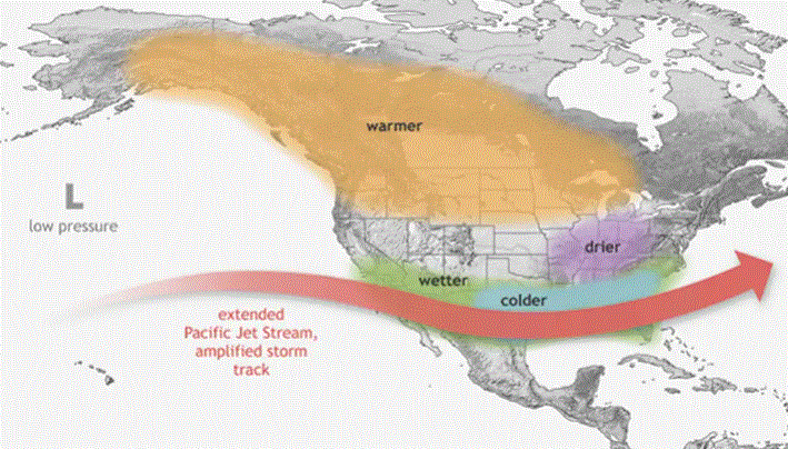
The map below shows the frequency of wet (blue/green) or dry (brown) winters (December-February) across North America during the 29 El Niños from 1940-2022. Places where more than half the El Niño winters were wetter than average by any amount are colored green. (Whether a winter was above- or below-average was based on comparison with a 30-year rolling average centered on the winter in question.) Places where more than half the El Niño winters were drier than average by any amount are colored brown. Much of the southern United States is light or medium green, meaning that wetter-than-average winters were slightly more common than drier-than-average winters. Across the northern part of the contiguous United States, drier-than-average winters slightly outnumbered wet ones.

“The strength of an El Niño event matters because the stronger the event, the more likely we’ll see the characteristic changes in temperature, rain and snow, and other impacts,” NOAA said. “It doesn’t necessarily mean that the impacts themselves will be so much stronger, but it makes the expected El Niño impacts more likely to happen.”