National Current Conditions: January 3, 2024 - January 9, 2024
The extreme weather from the last few days improved drought in the South and East. The Plains had a wet week too. Meanwhile, extremely low snowpack in the West led to degradations in many states.
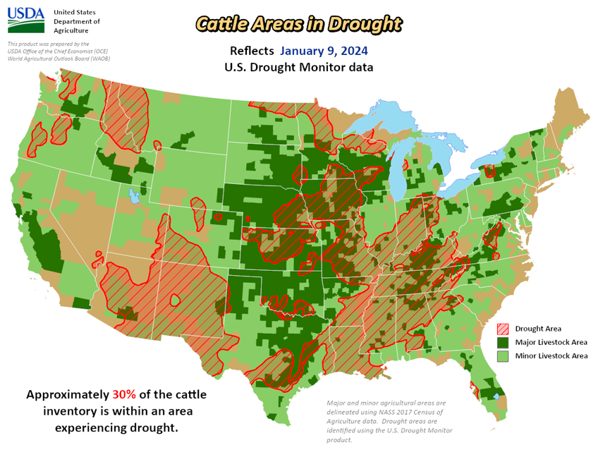
As of January 9, 2024, 26.71% of the U.S. and Puerto Rico and 31.91% of the lower 48 states are in drought, according to the U.S. Drought Monitor.


This Week's Drought Summary…
It was a stormy week across much of the eastern lower 48 states leading to widespread drought improvements east of the Rockies. A winter storm pummeled the Mid-Atlantic and Northeast over the weekend (January 6-7). Then a second system in its wake was ramping up across the Mississippi Valley toward the end of this week (Tuesday, January 9), bringing heavy rainfall to the Lower Mississippi and the Deep South. More than 2 inches of rain fell in many areas, with localized amounts upwards of 5 inches. Heavy snow also fell across parts of the Central Plains and Midwest as it moved slowly eastward, with snowfall still ongoing across parts of the Midwest and Great Lakes by the end of this week. Across the Intermountain West, it was a wet and snowy week mainly for parts of the Pacific Northwest and isolated locations in the Great Basin and Four Corners region, leading to some targeted improvements. However, several areas experiencing antecedent dryness and drought missed out on the precipitation, leading to further degradations, particularly across the northern Rockies, Front Range, and across parts of the western Colorado Plateau in Arizona. In Alaska, no changes to the drought depiction are warranted this week. In Hawaii, a Kona low spinning off to the north brought heavy bands of precipitation to western portions of the island chain, warranting some improvements to drought conditions. Conversely, another week of warm temperatures and below normal rainfall in Puerto Rico resulted in widespread deterioration of the drought depiction.
Looking Ahead...
During the next five days (January 11-15), a storm system is forecast to develop and intensify east of the Rockies, bringing potentially heavy rain and snow to parts of the eastern U.S. In the wake of this storm system bitterly cold temperatures are forecast to spill southward from Canada, leading to dangerously cold temperatures and wind chills across portions of the central and northern U.S.
The 6-10 day outlook (valid January 16-20), favors enhanced chances of below normal temperatures across much of the lower 48 states, with the highest chances (greater the 90%) centered over the Middle Mississippi Valley. Conversely, above normal temperatures are favored in the southwest U.S., underneath a mid-level ridge of high pressure that is forecast. Below normal precipitation is favored across many areas east of the Rockies during the next 6-10 days, as dry air moves in behind a departing storm system. However, a frontal boundary is forecast to remain draped across the Gulf of Mexico, bringing increased above normal precipitation chances to southern Texas and the Florida Peninsula. Above normal precipitation is also favored across parts of the West Coast, northern Rockies, and northern High Plains, associated with moist southwesterly flow into the northwestern U.S.


