National Current Conditions: February 7, 2024 - February 13, 2024
Nationwide drought coverage improved for the 6th straight week, including improvements for the Plains, Southwest, and South/Southeast. The Northern Rockies, Montana/Wyoming border, and Southeast Texas were the primary areas that worsened.
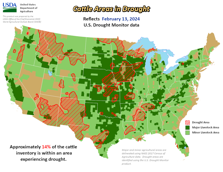
As of February 13, 2024, 16.32% of the U.S. and Puerto Rico and 19.46% of the lower 48 states are in drought, according to the U.S. Drought Monitor.


This Week's Drought Summary…
Last week, another round of Pacific storms swept across the West, bringing rain and mountain snow. Storms left over 3 feet of snow in the northern Arizona mountains before dropping more than a foot of snow in the mountains of Colorado and New Mexico. After a slow start to the year, basin snowpack in the Southwest has returned to near-normal conditions. Southwestern states saw improvements to short- and long-term drought conditions. In the Northwest, basin snowpack remains below normal with some of the worst conditions in the northern Rocky Mountains. The lack of snow led to the expansion of drought conditions. The wet pattern continued in the South and Southeast. In the last 30 days, rainfall totals of more than 10 inches (200 to 400 percent of normal) fell in parts of the South and Southeast.
The excess rain brought additional one-and two-category improvements to drought. The Northern Plains and Upper Midwest stayed relatively dry, with temperatures well above normal for the second week in a row. States in the Southern Plains saw pockets of improvements as long-term moisture deficits are finally showing signs of improvement. The winter storm that brought heavy snow to the Northeast on Wednesday occurred at the data cutoff for this week’s map.
Looking Ahead...
The National Weather Service Weather forecast (valid February 15 – 17, 2024) calls for another round of rainfall to push into the West Coast, bringing heavy rain and high elevation snow to the Cascades, Sierra Nevada, and the Northern Rockies. Polar air from Canada is expected to bring cold, dry air into the Northern Plains. Snow is expected across the Central Plains and Ohio Valley. Heading into the weekend, the extended forecast (valid February 17 - 21, 2024) calls for increased chances of multiple atmospheric river events for parts of central and southern California. Areas of lighter precipitation may spread across other parts of the west. The Upper Midwest and Northeast may see some snowfall. Storms tracking across the Gulf of Mexico may bring rain to Florida.
The 6-to-10-day outlook (valid February 20 – 24, 2024) calls for an increased probability of above-normal temperatures across most of the continental U.S. (CONUS) and Alaska. Temperatures across southern California, the East Coast, and northern Alaska are expected to be near to below normal. Increased precipitation is expected across California, the interior West, southern Alaska, and the Northeast. Much of the remaining CONUS, northern Alaska, and the Big Island of Hawaii are expected to have below- or near-normal precipitation.