National Current Conditions: February 14, 2024 - February 20, 2024
Drought continues to worsen in northern areas—the Northern Rockies and the Upper Midwest—and improve in southern areas—the Southwest and South/Southeast. Worsening drought in west Texas is one anomaly.
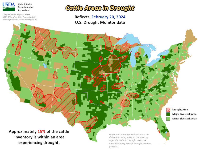
As of February 20, 2024, 16.62% of the U.S. and Puerto Rico and 19.82% of the lower 48 states are in drought, according to the U.S. Drought Monitor.


This Week's Drought Summary…
An atmospheric river of Pacific storm systems slammed parts of the West Coast with heavy precipitation during this U.S. Drought Monitor (USDM) week (February 14-20). The weather systems dried out as they crossed the western mountains, then produced anemic precipitation amounts east of the Rockies. Parts of the Midwest and Northeast received limited precipitation amounts from passing cold fronts, and heavier rain fell along the Texas coast and across Florida from another frontal system, but much of the country east of the Rockies, as well as the southwestern U.S., received little to no precipitation. The weather systems distorted the upper-level circulation over the contiguous U.S. (CONUS), which otherwise consisted of a high-pressure ridge over western North America and a low-pressure trough over the east. The end result of this distortion was a temperature anomaly pattern that consisted of warmer-than-normal weekly temperatures in the Upper Midwest and parts of the interior West, and below-normal temperatures in the Pacific Northwest, Rockies, and southern tier states, with near-normal temperatures elsewhere.
An upper-level ridge over the Caribbean brought generally dry and warmer-than-normal weather to Puerto Rico and the U.S. Virgin Islands, while ridges also kept Alaska mostly drier and warmer than normal and Hawaii drier than normal this week. Drought or abnormal dryness expanded or intensified this week in parts of the Pacific Northwest, northern Rockies, northern Plains, Upper Midwest, Middle Mississippi Valley, Rio Grande Valley, eastern North Carolina, and much of Hawaii. Drought or abnormal dryness contracted or reduced in intensity in parts of the Four Corners states and Lower Mississippi Valley.
Looking Ahead...
In the two days since the Tuesday valid time of this USDM, Pacific moisture continued to move across parts of the West, with little precipitation falling east of the Rockies. For February 22-27, one weather system will move across the eastern CONUS, while another moves into the West by the end of the period. The first is forecast to drop 0.5 to 1.5 inches of precipitation across the Tennessee Valley and southern Appalachians northward to the southern Great Lakes and central Appalachians, with half of an inch or less over the Northeast and even less over the Southeast. The second is expected to bring an inch or more of precipitation to the central and northern Rockies, coastal ranges of the Pacific Northwest, and Sierra Nevada, with up to 3 or 4 inches in the Washington Cascades. Other areas of the West are forecast to receive less than half an inch of precipitation, with little to no precipitation over the Southwest and to the lee of the Cascades in Washington. For the Great Plains to Mississippi Valley, little to no precipitation is predicted. Temperatures are expected to be warmer than normal, with the warmest anomalies across the Plains and Mississippi Valley due to upper-level ridging.
For much of the next 2 weeks, the atmospheric circulation is expected to consist of an upper-level trough over the western CONUS and a ridge over the eastern two-thirds of the country, with Pacific weather systems migrating through the trough/ridge pattern. The Climate Prediction Center’s (CPC) 6-10 Day Outlook (valid February 27-March 2) and 8-14 Day Outlook (valid February 29-March 6) favor a fairly stable pattern of warmer-than-normal temperatures from the Plains to East Coast and cooler-than-normal temperatures over the West and Alaska. The outlook is for above-normal precipitation over much of the CONUS, especially along the West Coast and Great Lakes, with odds favoring near to below-normal precipitation across the Plains and over most of Alaska.


