National Current Conditions: January 31, 2024 - February 6, 2024
Nationwide drought improved for the fifth straight week, with almost all improvements across the southern U.S. A few areas of Abnormal Dryness (D0) emerged (for example, in Montana), but conditions were mostly status quo otherwise.
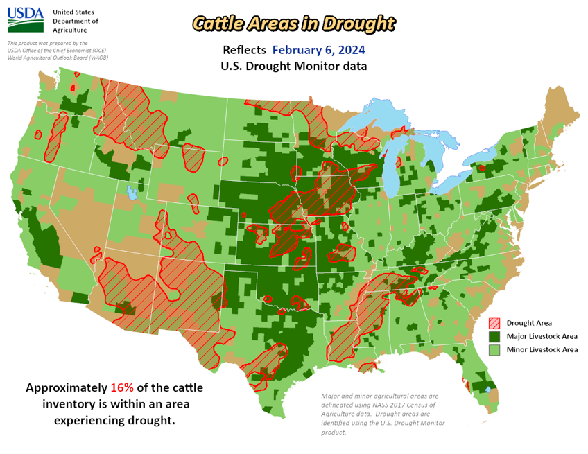
As of February 6, 2024, 17.79% of the U.S. and Puerto Rico and 21.22% of the lower 48 states are in drought, according to the U.S. Drought Monitor.


This Week's Drought Summary…
Last week, a strong Pacific storm system brought flooding rains to California and heavy snow to the mountain ranges of Northern California and the Sierra Nevada. Parts of the state saw nearly a foot of rain from this storm, breaking long-standing records. Moisture from this system also brought rain and snow to the Pacific Northwest and inland regions of the West. Most states in the region saw pockets of improvement despite the heaviest precipitation missing many of the West’s persistent drought areas. Another round of showers and thunderstorms passed through the South and Southeast.
In the last two weeks, rainfall totals of more than 10 inches fell in parts of East Texas, Louisiana, and Mississippi. The excess rain brought one and two category improvements to drought. The Northern Plains, Upper Midwest, and Northeast stayed relatively dry, with well above normal temperatures last week. Concerns continue to grow over the lack of snow this season.
Looking Ahead...
The forecast (valid February 7 – 10, 2024) calls for another round of rainfall to sweep across California and into the Desert Southwest. High elevation snow is expected over mountains in the West with a wintry mix (freezing rain, sleet, and snow) over the northern Plains and upper Midwest.
Heading into the weekend, the extended forecast (valid February 10 - 14, 2024) calls for a band of heavy rain across the South and Southeast. High temperatures are expected remain above average across central and eastern parts of the country.
The 6-to-10-day outlook (valid February 13 – 17, 2024) calls for an increased probability that observed temperatures, averaged over this 7-day period, will be above normal across the Upper Midwest, the west Coast, and Alaska. Temperatures across the remaining parts of the country are expected to be near to below normal. The pattern of increased precipitation across California and the southern tier of the continental U.S. (CONUS) is expected to continue, while much of the remaining CONUS, eastern Alaska, and the Big Island of Hawaii are expected to have below or near-normal precipitation.