National Current Conditions: April 3, 2024 - April 9, 2024
Like last week, drought and dryness in parts of Washington, the Central and Southern Plains, and the area around the Ohio and Mississippi River confluence worsened. Meanwhile, parts of the Rockies, Northern Plains, Southwest, and Midwest improved.
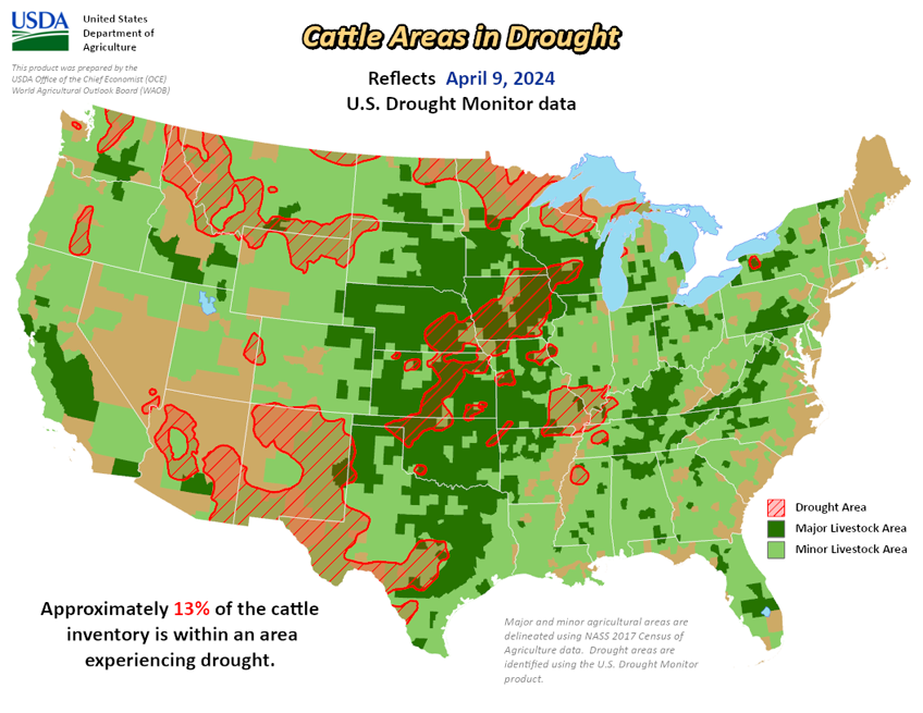
As of April 9, 2024, 14.66% of the U.S. and Puerto Rico and 17.46% of the lower 48 states are in drought, according to the U.S. Drought Monitor.


This Week's Drought Summary…
Following the El Nino winter and an active early spring pattern, drought coverage is at its lowest since the spring 2020. A strengthening low pressure system and trailing cold front progressed east from the Mississippi Valley to the East Coast at the beginning of April. This storm brought heavy snow (6 to 18 inches, locally more than 2 feet) to the Upper Peninsula of Michigan, Wisconsin, and northern New England. The recent precipitation (rain and snow) during the past few weeks continued to ease drought conditions across the Upper Midwest. From April 5 to 7, a strong storm system tracked east from the Rockies to the Great Plains. Heavy snowfall (6 to 12 inches, locally more) occurred across parts of Idaho, Montana, and Wyoming. Total precipitation amounts of 1 to 2 inches, liquid equivalent, resulted in drought improvement from the north-central Rockies to western South Dakota. Drought continued to develop or intensify across parts of the southern Great Plains and lower Ohio Valley along with Hawaii. Please note that heavy rainfall across the South, occurring after April 9th at 8am EDT, will be considered in next week’s U.S. Drought Monitor.
Looking Ahead...
During the next five days (April 11-15, 2024), a low pressure system and trailing cold front will move offshore of the East Coast on April 11th. Locally heavy rainfall (more than 1 inch) is forecast to accompany this cold front. From April 12 to the 14th, much drier weather is forecast throughout the eastern and central U.S. By April 14th, another low pressure system is expected to track inland to the West with additional rain and high-elevation snow. Later on April 15th, another round of wet weather is anticipated for the northern Great Plains and Midwest.
The 6-10 day outlook (valid April 16-20, 2024) favors above-normal temperatures across the eastern and southern contiguous U.S. (CONUS) with below-normal temperatures most likely across the northern Great Plains, northern to central Rockies, and Pacific Northwest. Increased above-normal precipitation probabilities are forecast for most of the eastern and central CONUS excluding Florida where below-normal precipitation is slightly favored. Below-normal precipitation is also more likely along the West Coast.