National Current Conditions: April 17, 2024 - April 23, 2024
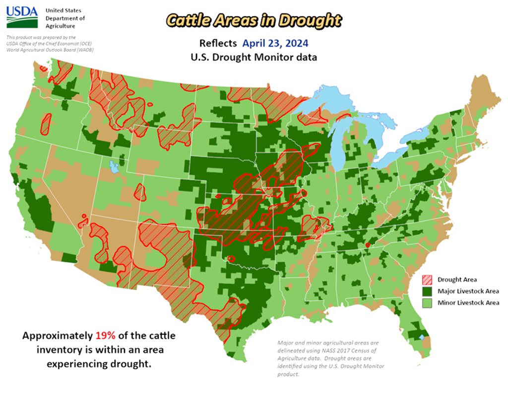
Drought expanded again in the Central and Southern Plains, particularly Kansas and Oklahoma. Drought also expanded in the Northwest and Northern Rockies. Meanwhile, the Northern Plains and Southwest saw improvements this week. The Midwest saw a mix of improvements and degradations.
As of April 23, 2024, 15.14% of the U.S. and Puerto Rico and 18.04% of the lower 48 states are in drought, according to the U.S. Drought Monitor.


This Week's Drought Summary…
This U.S. Drought Monitor (USDM) week saw improvements on the map in drought-affected areas of the Southwest, Northern Plains, and the Midwest while conditions deteriorated in areas of the Pacific Northwest, Eastern Plains of Colorado and Montana, Southern Plains, and the South. In the Pacific Northwest, a combination of factors (below-normal snowpack conditions, short-term dryness, low streamflows) led to expansion of areas of Abnormally Dry (D0) and Moderate Drought (D1) in western portions of Oregon and Washington. In Montana, poor snowpack conditions in the northwestern and west-central part of the state led to expansion of areas of Extreme Drought (D3) where some SNOTEL stations were reporting record or near-record low snow-water equivalent (SWE) levels. In the Southern Plains, drier-than-normal conditions during the past 30-90-day period in addition to low streamflows, declining soil moisture, and impacts to crops led to expansion of areas of Moderate Drought (D1) and Severe Drought (D2) in Oklahoma and Kansas. Conversely, wetter-than-normal conditions have prevailed during the past 30-60 days in portions of the Midwest leading to widespread improvements across drought-affected areas of Iowa, Minnesota, Wisconsin, and Michigan.
Likewise, improvements were made on the map in areas of the Southwest (Arizona and New Mexico) in response to beneficial precipitation received across much of the region since the beginning of the Calendar Year (January 1). In California, snowpack conditions moving into late April (4/24) were near normal levels with the statewide snowpack at 97% of normal, according to the California Department of Water Resources. Elsewhere in the West, below-normal SWE levels have persisted in the mountain ranges of Washington, northern Idaho, Montana, and northeastern Wyoming. According to the Natural Resources Conservation Service (NRCS) SNOTEL network (4/23), region-level (2-digit HUCs) median SWE levels are as follows: Pacific Northwest 75%, Souris-Red-Rainy 76%, Missouri 80%, California 95%, Great Basin 108%, Upper Colorado 87%, Lower Colorado 145%, Rio Grande 78%, and Arkansas-White-Red 79%.
Looking Ahead...
The NWS 7-Day Quantitative Precipitation Forecast (QPF) calls for moderate-to-heavy precipitation accumulations ranging from 2 to 5+ inches (liquid) across western Washington and Oregon as well as eastern portions of the Southern and Central Plains and lower Midwest. Lighter accumulations (< 2 inches) are expected in areas of the Central and Northern Rockies and Upper Midwest, while isolated light shower activity is expected in portions of Northern California, the Great Basin, and the Northeast.
The 6-10 Day Outlooks call for a moderate-to-high probability of above-normal temperatures across most of the conterminous U.S., with the exception of the Far West, and the western Great Basin where cooler-than-normal temperatures are expected. In Alaska, there is a low-to-moderate probability of above-normal temperatures in the southern half of the state and below-normal temperatures north of the Brooks Range. In terms of precipitation, below-normal precipitation is expected across the Eastern Tier of the conterminous U.S. as well as out West in western Colorado, Utah, and southern Nevada. Elsewhere, there is a high probability of above-normal precipitation across the Pacific Northwest, Northern California, eastern New Mexico, Texas, the Plains states, and the Upper Midwest.