National Current Conditions: May 22, 2024 - May 28, 2024
This past week brought more severe storms and lots of precipitation in parts of the Plains and Midwest. However, the same areas keep missing out, including western Kansas/Oklahoma, eastern Colorado, South Florida, and parts of the Northwest.
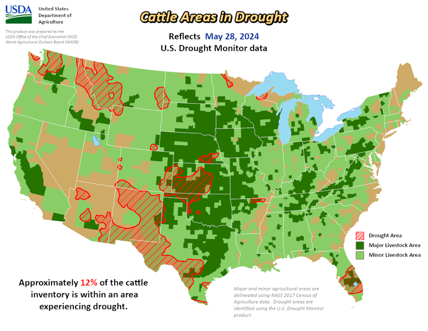
As of May 28, 2024, 10.50% of the U.S. and Puerto Rico and 12.55% of the lower 48 states are in drought, according to the U.S. Drought Monitor.


This Week's Drought Summary…
A front over the Northwest to the Great Basin brought rain and higher-elevation snow to parts of the region, as well as rain and extreme weather to most of the Plains and Lower Mississippi Valley as the front advanced eastward. An additional front from southern Plains to the Great Lakes brought severe weather and thunderstorms from Texas to New York. Meanwhile, a sub-tropical upper-level high over Mexico brought record- to near-record warmth to portions of Texas. Temperatures were above normal across the eastern contiguous U.S., by as much as 10+ degrees F above average from parts of the eastern Great Lakes to the Northeast and in parts of Texas.
Precipitation was below normal across much of the southern contiguous U.S. and the Northeast, as well as portions of the Northwest and parts along the East Coast. The most widespread improvements were made to portions of the Midwest and in eastern parts of the High Plains and South, as well as Montana and Hawaii, where above-normal precipitation was observed this past week. Dry conditions continued across the western portions of the Southern region, southern High Plains and Southeast, with degradations occurring in parts of the western Plains and Florida Peninsula. Drought and abnormal dryness also expanded or intensified in portions of the northern Rockies and Pacific Northwest. In Alaska, heavy rainfall resulted in the removal of abnormal dryness from the central interior this week.
Looking Ahead...
During the next five days (May 28–June 1, 2024), moisture convergence along a frontal boundary and east of a dryline across Texas and Oklahoma will likely generate scattered to numerous showers and thunderstorms, with the potential for episodes of locally heavy rainfall early to mid-week. The threat of heavy rainfall will be highest in Texas Tuesday into Wednesday as an upper level shortwave moves over the southern Plains, where the potential exists for storms with rainfall rates approaching 2 inches per hour. The coverage of showers and storms will likely expand north across the central and northern Plains later in the week as an organized frontal system moves into the central U.S. from the Rockies. Locally heavy rainfall will be possible across portions of the Rockies going into late Friday and early Saturday as the cold front intercepts an increasingly humid airmass. In terms of temperatures, the Gulf Coast region will continue to remain hot and humid on Tuesday before some limited relief arrives by midweek as a cold front drops southward. However, the heat and humidity will likely continue across Deep South Texas and South Florida with highs running up to 10 degree above average, and heat indices in the 100-110 degree range, especially for southern Texas. Some triple digit heat is also likely for the lower elevations of the Desert Southwest, but very low humidity here will help keep heat indices in check.
The Climate Prediction Center’s 6-10 day outlook (valid June 2–6, 2024) favors above-normal precipitation along much of the West Coast, from the southern Plains to the East Coast, and across much of Alaska, with below-normal precipitation across most of the interior West and Hawaii. Increased probabilities for above-normal temperatures are forecast for Hawaii and much of the contiguous U.S., while below-normal temperatures are likely across the state of Alaska and in parts of Georgia and South Carolina.