National Current Conditions: May 15, 2024 - May 21, 2024
The wet spring continues. Drought improved across the U.S. this week, especially in the Midwest and Northern Plains. However, a few areas keep missing out, including the Southwest, western Texas, western Kansas, and South Florida.
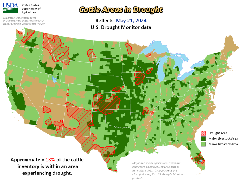
As of May 21, 2024, 10.51% of the U.S. and Puerto Rico and 12.55% of the lower 48 states are in drought, according to the U.S. Drought Monitor.


This Week's Drought Summary…
This U.S. Drought Monitor (USDM) week saw widespread improvement in drought-related conditions on the map across areas of the South, Plains, Midwest, Mid-Atlantic, and the West. In the Plains and Midwest, locally heavy rainfall accumulations (up to 7 inches) were observed in drought-affected areas of Oklahoma, Kansas, Nebraska, Missouri, and Iowa leading to continued improvements of conditions on the ground (vegetation health, soil moisture, surface water) as well as reductions in the longer-term precipitation deficits. Likewise, above-normal precipitation during the past several months led to removal of areas of drought on the map in Michigan’s Upper Peninsula as well as in southern Wisconsin. In the South, isolated areas of central and west-central Texas saw minor improvements in response to recent rains and improving conditions during the past 30-day period. In the Mid-Atlantic, 1-6-inch accumulations were observed in areas of North Carolina and Virginia this week leading to removal of areas of Abnormally Dry (D0).
Out West, some minor improvements were logged in central and northern Arizona where precipitation has been above normal since January 1. In southeastern Montana, recent rains erased Water Year (since October 1) deficits and have improved soil moisture conditions and vegetation health. Across the border in the Bighorn Mountains of north-central Wyoming, areas of Moderate Drought (D1) were removed in response to above-normal snowpack conditions observed in its associated drainage basins. In California, the state’s reservoirs are above normal levels moving into the dry season with the state’s two largest reservoirs (Lake Shasta and Lake Oroville) at 115% and 126% of their historical average for the date (May 21), respectively.
In the Southwest, Lake Powell is currently 33% full (58% of typical storage level for the date) and Lake Mead is 35% full (62% of average) with the total Lower Colorado system at 42% full as of May 20 (compared to 37% full at the same time last year), according to the U.S. Bureau of Reclamation. In Arizona, the Salt River Project is reporting the Salt River system reservoirs at 95% full, the Verde River system at 70% full, and the total reservoir system at 92% full (compared to 99% full a year ago). In New Mexico, the state’s largest reservoir along the Rio Grande is currently at 23% full (59% of average). In the Pacific Northwest, Washington’s Franklin D. Roosevelt Lake is at 87% full (176% of average for the date).
In terms of degradations on the map this week, the only noteworthy ones were made in areas of South Florida where areas of Moderate Drought (D1) expanded in response to dry conditions during the past 60-day period with reports of various impacts including burn bans, lake levels dropping at Lake Okeechobee, reduced soil moisture, and some minor impact in the recreation sector due to low surface water levels. Overall, looking at the broader drought situation across the conterminous U.S., the total percentage of drought coverage is at its lowest since 2020.
Looking Ahead...
The 7-Day Quantitative Precipitation Forecast (QPF) calls for moderate-to-heavy rainfall accumulations ranging from 2 to 5 inches across areas of the eastern portions of the Southern Plains (Oklahoma), South (northeastern Texas, Arkansas, northern Mississippi, Tennessee, Kentucky) and the Midwest (Illinois, Indiana, Ohio) while lesser accumulations (1 to 2.5 inches) are expected in areas of the Upper Midwest, Mid-Atlantic, Northeast, and out West in isolated areas of the Northern Rockies, and eastern plains of Montana. Dry conditions are expected across California, the Great Basin, the Southwest, and the southern extent of the Intermountain West. Likewise, much of the Gulf Coast region is expected to experience relatively dry conditions.
The 6-10-day Outlook calls for a moderate-to-high probability of above-normal temperatures across much of the South, Southeast, lower Mid-Atlantic, and northern portions of the Northeast. Likewise, above-normal temperatures are expected across most of the western U.S., with the exception of the Far West coastal areas from California to Washington where near-normal temperatures are expected. Conversely, below-normal temperatures are expected in eastern portions of the Central Plains and across much of the Midwest. In terms of precipitation, there is a low-to-moderate probability of above-normal precipitation across the South, Southeast, Mid-Atlantic, and Northeast, while below-normal precipitation is expected across most of the western U.S., Northern Plains, and areas of the Upper Midwest.