National Current Conditions: May 8, 2024 - May 14, 2024
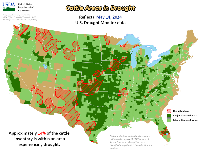
As of May 14, 2024, 11.71% of the U.S. and Puerto Rico and 13.98% of the lower 48 states are in drought, according to the U.S. Drought Monitor.


This Week's Drought Summary…
Heavy precipitation fell across the Rocky Mountains of Montana, Wyoming and Colorado, as well as a large part of the South and southern Midwest. This brought widespread improvements to much of the South and Midwest, with scattered or widespread improvements in the Great Plains and Midwest. Heavy precipitation falling over the Southeast brought improvements from central Alabama into the southern Appalachian Mountains, as well as the area surrounding the convergence of the Ohio, Mississippi, and Tennessee rivers. A small area of the Mid-Atlantic region missed out on much of the precipitation, leading to minor degradations. Very dry weather for the past few months led to increased fire danger in parts of the Florida Peninsula, and short-term moderate drought and abnormal dryness expanded in coverage. Texas saw isolated degradations in the panhandle and south – where record breaking temperatures converged with the lack of precipitation.
The High Plains were a mixture of light to moderate precipitation, which greatly influenced where improvements or degradations were made. Kansas, Colorado and Wyoming saw improvements where measurable precipitation fell. Degradations occurred in western Kansas and eastern Wyoming, where trace amounts of precipitation fell. Montana saw heavy precipitation, which improved conditions across much of the state. Isolated storms in western Oregon and Washington brought widespread improvements in Oregon, which continued into southwestern Washington. Central Washington, meanwhile, missed out on the precipitation and saw further expansion of abnormal dryness.
Looking Ahead...
Over the next five days (May 16-21), heavy precipitation of2 to 5 inches is expected to continue to fall in the far South from central Texas to western Georgia, with 1 to 2 inches of rain expected in surrounding areas into the southern Midwest and Mid-Atlantic coast. The rest of the central and eastern United States will see some light precipitation. Much of the West will miss out on this precipitation.
The 6-10 day outlook heavily favors above-normal temperatures from New Mexico to Wisconsin, Maine, and down into Florida, with the greatest possibility being in southern Texas. The Southwest and High Plains are expected to be near normal temperature and everything to the west is likely going to be cooler than normal. Hawaii and northern Alaska are likely going to be warmer than normal, whereas parts central and western Alaska are leaning towards below-normal temperatures. For precipitation, much of the country is leaning towards above-normal precipitation. New Mexico and central and southern Texas are leaning toward below-normal precipitation, with the western and eastern coasts likely to be around normal. The Big Island of Hawaii is likely to see above-normal precipitation, along with central and northern Alaska. Southern Alaska is leaning toward below-normal precipitation.