National Current Conditions: April 24, 2024 - April 30, 2024
For the third week in a row, drought worsened in western Kansas and Oklahoma. However, eastern Kansas and Oklahoma saw improvements. Drought was introduced to Florida and added to southeast Montana. The Midwest saw big improvements.
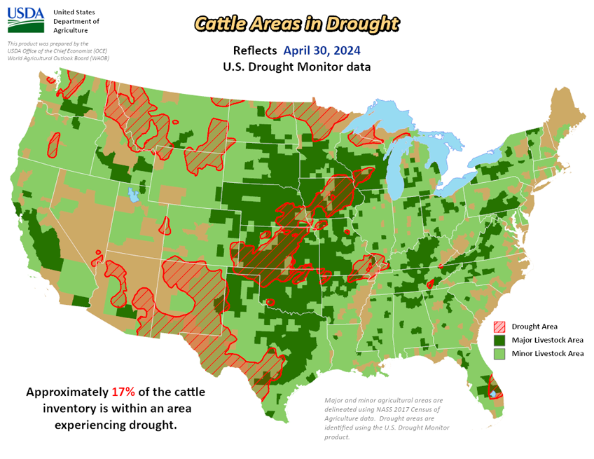
As of April 30, 2024, 14.23% of the U.S. and Puerto Rico and 16.96% of the lower 48 states are in drought, according to the U.S. Drought Monitor.


This Week's Drought Summary…
During the late week and weekend, a large severe weather outbreak brought large hail, damaging winds and numerous intense tornadoes to parts of the central and southern Great Plains and Midwest. The storm systems responsible for the severe weather outbreak also brought widespread moderate and heavy rain amounts to the central U.S., leading to widespread improvements in drought and abnormally dry conditions. To the southwest of the heavy rainfall, in northwest Oklahoma and southwest and central Kansas, severe drought expanded as flash drought continued to take hold during a very dry late winter and early-mid spring, leading to reports of very poor wheat conditions and dust storms. Recent dry weather over the last month, combined with a mostly dry week, led to the development of more areas of abnormal dryness and moderate drought over scattered parts of the Southeast, Tennessee and southeast Kentucky. Conditions mostly remained unchanged in the western U.S., though a few improvements occurred in Colorado and Utah after recent precipitation, while conditions worsened in parts of southeast Montana and the Black Hills region of South Dakota and adjacent northeast Wyoming amid recent dry weather. Heavy rains in the northeast part of Puerto Rico eased drought and abnormal dryness there as streamflows improved and crop stress lessened.
Looking Ahead...
Between Wednesday, May 1 (time of writing), and the evening of Monday, May 6, the National Weather Service Weather Prediction Center is forecasting moderate to heavy rain amounts from central Texas and northern Louisiana northward into the mid-Missouri and upper-Mississippi River valleys. In this region, rainfall amounts are forecast to range from a half inch to locally as high as 3 inches, especially in parts of Oklahoma, Texas and northern Louisiana. Similar precipitation amounts are also forecast in western Washington and Oregon, while some precipitation exceeding 1 inch is also forecast in parts of the northern Sierra Nevada. Mostly dry weather is forecast for eastern Colorado, New Mexico, Arizona, southwest Nevada, southern California and deep south Texas.
For May 7-11, the National Weather Service Climate Prediction Center’s forecast favors colder-than-normal weather across much of the western U.S., with the highest confidence for colder-than-normal weather centered over Idaho and northern Nevada. Warmer-than-normal weather is expected in much of the southeast half of the contiguous U.S., especially from Texas northeast to the mid-Atlantic. Above-normal precipitation is favored in the northern U.S., especially eastern Montana, while below-normal precipitation is favored in coastal California, southern New Mexico and southern and western Texas, southeast Louisiana and most of Florida.
During the May 7-11 period, colder-than-normal temperatures are favored in southwest, south-central and southeast Alaska, and across all of Hawaii. All of Alaska is favored to receive above-normal precipitation, with confidence highest outside of the far west and northwest. With the exception of the Big Island, the forecast slightly favors above-normal precipitation in Hawaii.


