National Current Conditions: June 12, 2024 - June 18, 2024


This week brought a huge addition of Abnormal Dryness (D0) and some drought in the eastern third of the U.S., particularly the Ohio River Basin and Mid-Atlantic.
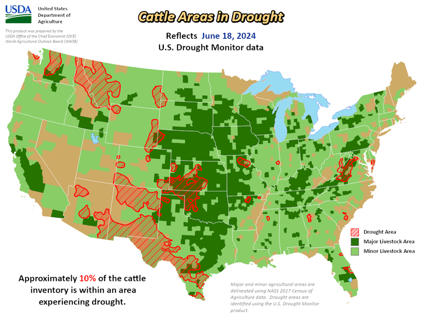
Not surprisingly, South Florida saw big improvements. As of June 18, 2024, 10.06% of the U.S. and Puerto Rico and 12.03% of the lower 48 states are in drought, according to the U.S. Drought Monitor.
This Week's Drought Summary…
There were big changes in the Drought Monitor depiction of dryness and drought this week compared to last, primarily across the contiguous U.S. east of the Mississippi River. Inundating tropical rains literally washed away the entrenched moderate to severe drought (D1 to D2) that had covered southern Florida. The opposite was the case farther north across most of the Eastern States. Rainfall has been generally below-normal across a majority of this region for the past 1 to 2 months, with subnormal rainfall dating back 3 or more months in some areas. Increasingly, above-normal temperatures have accompanied the dryness, which has added to the rate of surface moisture depletion. Temperatures have had the greatest impact on conditions in the climatologically-hotter areas across the South until late this past week, when excessive heat started to engulf the Great Lakes and Northeast.
Declining streamflows and dropping soil moisture started to become obviously apparent this past week over large sections of the East, and as a result, there was an expansive increase in new D0 coverage east of the Mississippi River and north of central Florida, with only small spots in Georgia and Maine experiencing any discernable relief. Farther west, although changes were not as expansive, both south-central and north-central portions of the Plains and Rockies also saw significant areas where dry conditions developed or intensified. There were other areas of heavy rain outside southern Florida, but most of it fell on sections of the Upper Midwest that have received consistently above-normal precipitation for at least several weeks, thus bringing no changes to areas of dryness and drought. West of the Mississippi River, limited improvement was introduced in relatively small swaths in northeastern Arkansas, central and western Kansas, southern Nebraska, southwestern Montana, and a few adjacent locales.
Looking Ahead...
In the 24 hours after the valid period for this Drought Monitor ended (8 a.m. EDT Tuesday June 18, 2024), excessive to historically heavy rains fell on the central Oklahoma Panhandle and some adjacent locales in Texas and, to a lesser extent, Kansas. Over 7 inches of rain inundated some sites in the central Oklahoma Panhandle during the 24-hour period. Climatologically, these amounts are expected only once every few hundred years, at most, in this region. During the next five days (June 20-24, 2024), moisture from the first named tropical system in the Atlantic basin this year (Tropical Storm Alberto) is expected to stream into southern Texas, dropping 3 to locally 8 inches of rain from Webb County (north of Laredo) and San Patricio County (north of Corpus Christi) southward into Mexico. An inch or more is possible as far north as Del Rio and East Matagorda Bay. Farther north, heavy to excessive rains of 3 to 6 inches are expected to drench a swath from southeastern South Dakota through much of southern Minnesota and into part of northern Wisconsin – an area frequently affected by heavy rains over the past several weeks – and a smaller area over southwestern Colorado. Amounts exceeding 1.5 inches are forecast from parts of the north-central Great Plains eastward through the upper Mississippi Valley and the northern and western Great Lakes region, with similar amounts expected over much of New England and adjacent eastern New York, part of northeastern Florida and some adjacent areas, and scattered higher elevations in northern New Mexico and western Colorado. In contrast, fairly dry weather – featuring a few tenths of an inch of precipitation at best – is expected in the areas of dryness and drought affecting the Far West, Intermountain West, central and northern Texas, most of Oklahoma, interior portions of the lower Mississippi Valley and Southeast, the lower Ohio and Tennessee Valleys, and the mid-Atlantic Piedmont. Other locations across the contiguous United States are forecast to receive near typical amounts for a week in mid-June.
Most of the contiguous states are expected to average warmer than normal for the 5-day period, with all areas north and east of the middle and lower Mississippi Valley, the immediate Gulf and South Atlantic Coasts, and Florida forecast to average at least 2 deg. F above normal. Similar anomalies are anticipated in the central and south-central Plains, the northern half of the Rockies, the Intermountain West, and the Far West. Parts of interior California, the northern Great Basin and adjacent northern Intermountain West, south-central Great Plains, and a large swath from the middle Mississippi Valley eastward through the mid-Atlantic and adjacent regions are expected to average 6 to 10 deg. F above normal. Subnormal mean temperatures should be confined to Deep South Texas, much of the Rio Grande Valley, much of the Big Bend, part of the upper Mississippi Valley, and portions of the immediate Pacific Coast
The Climate Prediction Center’s 6-10 day outlook (valid June 25-29, 2024) favors a continuation of above-normal temperatures over a vast majority of the contiguous states, with the greatest odds (over 80 percent) across much of the Four Corners region, and farther east over most of the Carolinas and Virginia. Enhanced chances for below-normal temperatures are restricted to part of the Pacific Northwest. Somewhat enhanced chances for abnormally high temperatures also cover most of Mainland Alaska while below-normal temperatures are favored in southeastern Alaska and across Hawaii. A large part of the contiguous states also show elevated chances for above-normal precipitation, although in most areas the shift of the odds is modest. There is a 33 to near 50 percent chance of surplus precipitation in the Pacific Northwest, most of the Four Corners region, and from the Plains eastward through the Mississippi and lower Oho Valleys, Great Lakes region, southern Appalachians, Southeast, and Florida. Odds for wetter than normal weather exceed 50 percent in much of Arizona and New Mexico. Neither abnormal wetness nor dryness is favored in the Northeast, mid-Atlantic region, northern Rockies, and Southwest while drier than normal conditions are only favored in the Great Basin and adjacent areas in the northern Intermountain West and California. Meanwhile, there are slightly increased odds for above-normal precipitation over the southeastern two-thirds to three-quarters of Alaska and throughout Hawaii.


