National Current Conditions: June 5, 2024 - June 11, 2024


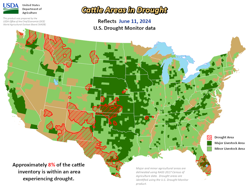
This week brought improvements in Kansas and New Mexico, two states that still have large areas of drought. The Midwest is now drought-free. Drought expanded in Texas and central/northern Florida, but Florida can expect heavy rainfall this week.
As of June 11th, 9.84% of the U.S. & Puerto Rico and 11.77% of the lower 48 states are in drought, according to the U.S. Drought Monitor.
This Week's Drought Summary…
A highly variable precipitation pattern was noted across the contiguous 48 states this past week, resulting in a significant number of changes in the Drought Monitor depiction. Another week of heavy rain June 4-11 continued to ease drought and abnormal dryness in parts of the central and southern Plains, with excessive amounts resulting in 2-category improvements in portions of central Kansas. Moderate to heavy rainfall also brought improvements to portions of the middle and upper Mississippi Valley, the Northeast, the Washington Cascades, and southernmost Florida. Meanwhile, deficient rainfall caused abnormal dryness and drought to expand or intensify in parts of southern New England, the mid-Atlantic region, the interior Southeast, the central and northern Florida Peninsula, a few scattered areas across Texas, part of the central Rockies, the northern High Plains, some sections of interior Washington and Oregon, and a small region in northeastern Alaska. Other areas were unchanged, including Hawaii and Puerto Rico.
Looking Ahead...
During the next five days (June 13-17, 2024), tropical moisture is expected to interact with mid-level low pressure across southern Florida, resulting in heavy rain. Flood watches are currently in effect, and 3 to 5 inches of rain are expected before precipitation tapers off later in the period. Tropical moisture from the Gulf of Mexico may also push into the central Gulf Coast region, bringing 1.5 to 2.5 inches of rain to the Louisiana Bayou and southern Mississippi. Farther north, thunderstorms along a frontal boundary are expected to drop 1.5 to 3.5 inches of rain on parts of the northeastern Great Plains and Upper Mississippi Valley. Moderate precipitation is expected in other parts of the northern Great Plains, upper and middle Mississippi Valley, western Great Lakes region, eastern New England, northern Florida Peninsula, southern lower Mississippi Valley, and higher elevations of the northern Rockies and Cascades. Meanwhile, the summer’s first extended period of excessive heat is forecast to develop toward the end of the period in the central Great Plains, expanding eastward across the middle and upper Mississippi Valley, the Ohio Valley, the mid-Atlantic region, and the Northeast by the end of the period. Highs well into the 90s should be widespread by the end of the period, and warm nighttime lows are expected, providing little relief. Subnormal temperatures are forecast to be limited to the Pacific Northwest.
The 6-10 day outlook (valid June 18-22, 2024) favors above-normal temperatures from the southern Rockies and most of the Plains eastward to the Atlantic Ocean, with the most prohibitive odds (over 80 percent) across the Northeast and New England away from the immediate Atlantic Coast. There is a good chance that excessive heat will continue through at least part of the period across central and northern parts of the U.S. from the Mississippi Valley eastward. Farther west, subnormal temperatures are favored in many areas, but only slightly, with odds remaining below 40 percent (climatological odds are 33 percent). Below-normal precipitation is favored across the mid-Atlantic region, the Carolinas, the upper Southeast, and the Ohio Valley, as well as southeastern Alaska. However, odds tilt toward above-normal precipitation over a larger area encompassing the Gulf Coast region, the northern and southern Great Plains, the High Plains, the Great Lakes Region, the southern Rockies, the northern tier of the contiguous U.S. from the northern Rockies to the Pacific Coast, northeastern Alaska, and Hawaii. The best chances for surplus rainfall (50 to 70 percent) cover southern Texas.


