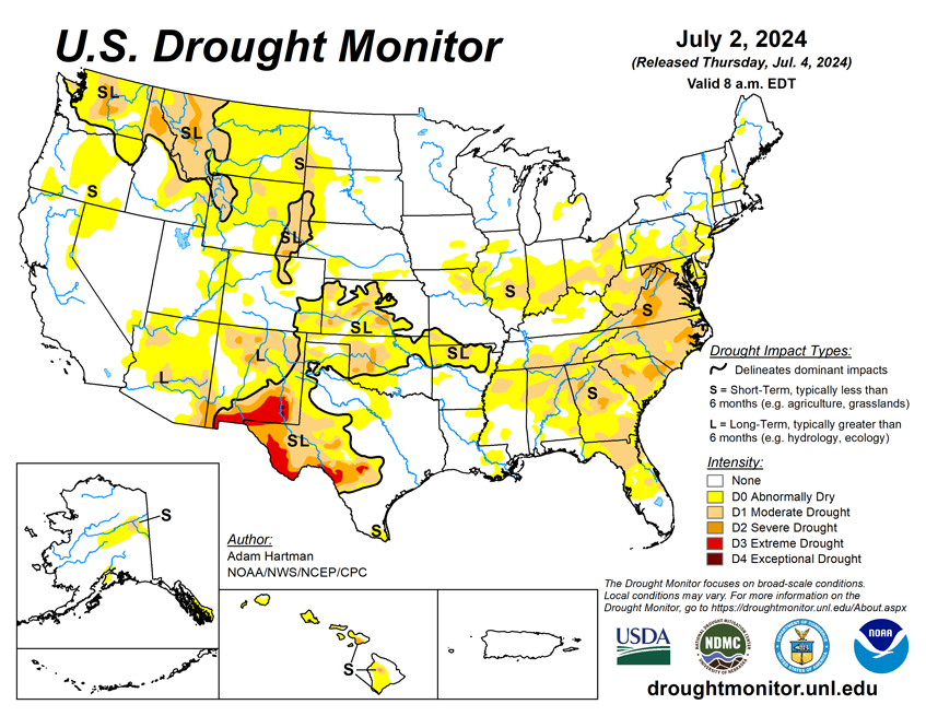

National Current Conditions: June 26, 2024 - July 2, 2024
Severe Drought (D2) has developed in Pennsylvania, Maryland, West Virginia, Virginia, North Carolina, South Carolina, and Georgia. The South, West Texas, Northwest, and Northern Rockies also saw conditions worsen. Meanwhile, the Plains and Midwest saw a mix of improvements and degradations.
As of July 2, 2024, 15.81% of the U.S. and Puerto Rico and 18.67% of the lower 48 states are in drought, according to the U.S. Drought Monitor.
This Week's Drought Summary…
East of the Rocky Mountains, there was a mixture of worsening and improving drought conditions this week. With the passage of a couple of frontal boundaries across the eastern contiguous U.S. (CONUS), in addition to a steady moisture flow from the southwestern CONUS into parts of the Central Plains, several areas across the eastern two-thirds of the U.S. received heavy precipitation. However, heavier amounts varied greatly from region to region and were highly localized east of the Mississippi River. Rates of evaporation of moisture from land and vegetation (known as evapotranspiration) are high across the eastern CONUS, due in large part to several days of excessive heat. Therefore, targeted improvements are depicted in regions picking up above normal precipitation (at least 1 inch above normal rainfall for the week) and where improvements to soil moisture and stream flows were apparent.
Given the very dry and hot antecedent conditions leading up to this week, drought degradation is merely halted in most other areas receiving above normal rainfall, as indicators did not show marked improvements. Conversely, for locations receiving below normal rainfall, another week of degradation is warranted. In the West, the Four Corners region was the beneficiary of yet another wet week, aided by a couple of low pressure systems bringing an influx of moisture into the region. Elsewhere in the West, conditions worsened, with several pockets of abnormal dryness (D0) popping up and the expansion of drought conditions, particularly across the northern Rockies. A slight westward expansion of abnormal dryness and moderate drought (D1) in the Alaska Mainland and the introduction of abnormal dryness near the Kenai Peninsula is warranted, supported by short-term derived drought indicators and precipitation deficits. A status-quo drought depiction is depicted in Hawaii this week, but stream flows are slowly falling as the trade winds continue to lack meaningful moisture. Puerto Rico continues to remain drought-free.
Looking Ahead...
During the next five days (July 3 - July 7), High pressure is likely to build over the western U.S., leading to hot, potentially record-breaking temperatures and below normal precipitation. Farther eastward, East of the Rockies, temperatures are forecast to become more seasonal for the most part. In addition, parts of the Middle and Upper Mississippi Valley are likely to experience a couple of rounds of heavy rainfall. Rainfall in excess of 1 inch is favored across parts of the Ohio Valley, Mid-Atlantic, and Southeast.
The 6-10 day outlook (valid July 8 - 12), favors enhanced chances of above average, potentially record-breaking, temperatures across parts of the Intermountain West, with above normal temperatures changes extending into the Western Plains, along the Gulf Coast, and into the eastern U.S. Below normal temperatures are favored in the interior central U.S. Near and below normal precipitation is likeliest across the western and north-central U.S., with above normal precipitation favored elsewhere. Eyes will be on the tropics over the next 6 to 10 days, with enhanced chances for above normal precipitation across southern Texas and the western Gulf Coast. Near to below normal temperatures and above normal precipitation is favored in Alaska and Hawaii.