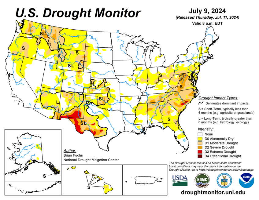

National Current Conditions: July 3, 2024 - July 9, 2024
This week brought many changes to drought and dryness due to Beryl and extreme heat. The northwestern U.S., Mid-Atlantic, and Southeast are now mostly dry or in drought. The Eastern Plains and Mississippi River Basin are almost drought-free.
As of July 9, 2024, 16.44% of the U.S. and Puerto Rico and 19.43% of the lower 48 states are in drought, according to the U.S. Drought Monitor.

This Week's Drought Summary…
The first landfalling tropical storm of the season came ashore in east Texas and brought significant precipitation to the area and up into the Ozark Plateau. Temperatures were cooler than normal over a large extent of the country from the Rocky Mountains and into the Plains and Midwest where departures from normal temperatures were 3-9 degrees below normal. Excessive heat dominated the West Coast where departures from normal temperatures over much of California were 12-15 degrees above normal. Many records were set, including 120 degrees in Las Vegas, beating the old record by 3 degrees, while Death Valley had 5 consecutive days with high temperatures over 125 degrees topping out at 129 on July 7. Near-normal to slightly above-normal temperatures dominated much of the East and Southeast. Along with the heat, much of the West was dry during the last week. Areas of the Plains recorded well above-normal precipitation with some areas receiving 400-800% of normal precipitation for the week. Spotty rains were common over the Southeast with a very typical summertime pattern of widely scattered thunderstorms accounting for most of the precipitation. The driest areas were from Mississippi and northern Alabama into Tennessee and the Mid-Atlantic. Portions of northern Illinois eastward into Ohio were also dry throughout the week.
Looking Ahead...
Over the next 5-7 days, some monsoonal precipitation is anticipated over portions of the Southwest, but most of the West overall remains quite dry. The dryness is anticipated to develop over much of the Plains and continuing over much of the Southeast. Coastal areas of the Gulf of Mexico and along the eastern seaboard are anticipating the most precipitation, with the greatest amounts from South Carolina into the Mid-Atlantic. The Midwest is anticipated to remain wet with this pattern extending into the Northeast. Temperatures are anticipated to be above normal over most of the country with the greatest departures from normal over the Pacific Northwest and in the Southeast into the Mid-Atlantic. The Southwest into western and southern Texas is anticipated to be cooler than normal, albeit slightly.
The 6-10 day outlooks show that much of the country is anticipated to have above-normal temperatures during the period, with the greatest chances over the northern Rocky Mountains and the Southeast. The highest chances of above-normal precipitation will be over the Four Corners region and along the Rio Grande in Texas as well as over the coastal regions of the Carolinas. The best chances of below-normal precipitation occurring are from the northern Rocky Mountains into the Great Basin and into central California.