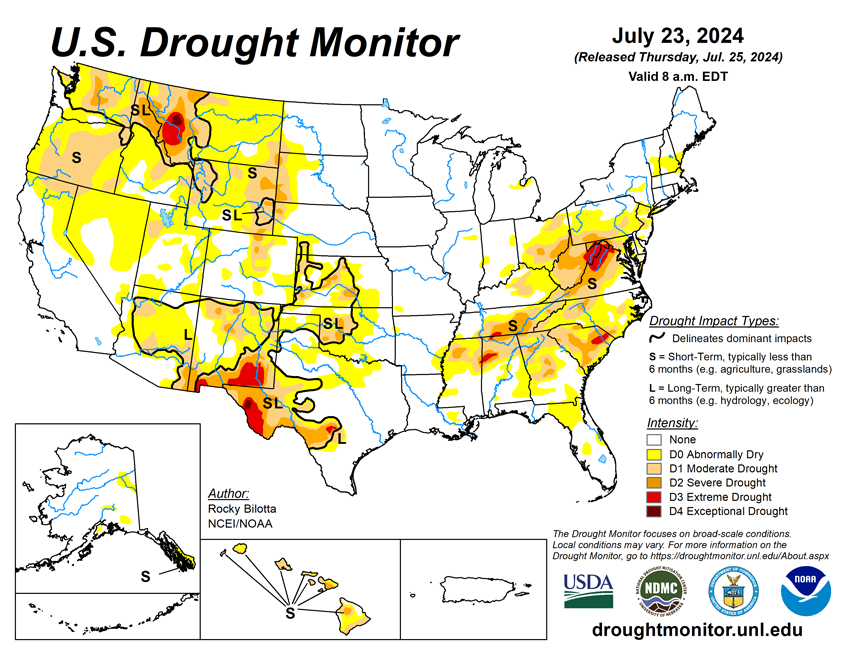

National Current Conditions: July 17, 2024 - July 23, 2024
More heat and dryness out West led to drought worsening in Northern California, the Northwest, Northern Rockies, into the Plains. The southern U.S. mostly improved, particularly New Mexico, Texas, and the South/Southeast.
As of July 23, 2024, 16.96% of the U.S. and Puerto Rico and 19.97% of the lower 48 states are in drought, according to the U.S. Drought Monitor.
This Week's Drought Summary…
Over the past week, a major heatwave brought warmer-than-normal temperatures to much of the West, with departures ranging between 3 to 12 degrees F above normal across much of the region. Near-normal to cooler-than-normal temperatures were observed from the central Rockies to the Great Lakes, with departures ranging between 3 to 9 degrees F below normal. Precipitation varied across the contiguous U.S. this week. Monsoonal moisture brought heavy precipitation and flash flooding to parts of the Southwest, while a lingering frontal boundary brought daily thunderstorms, heavy rainfall and flash flooding across much of the Southeast and Mid-Atlantic. The most widespread improvements were made in the Southeast, as well as eastern portions of the Southwest and across much of western Texas, where above-normal precipitation amounts were observed this past week. Conversely, dry conditions resulted in degradations across much of Hawaii and the Pacific Northwest, as well as southern portions of the Northeast and in parts of the central Plains, and other parts of the West. Drought and abnormal dryness also expanded or intensified in the Ohio Valley, western High Plains, and in New England. In Hawaii, dry conditions coupled with warmer temperatures resulted in the expansion and intensification of drought across the state this week.

Looking Ahead...
During the next five days (July 23–27, 2024), dangerous heat is expected to continue through the midweek across much of the West, with high temperatures reaching the 90s and 100s and ranging between 5-15 degrees above normal. The strong ridge, extending from the Southwest U.S. into west-central Canada, which produced hazardous heat from the West into the northern High Plains, should begin to weaken and begin to push eastward ahead of a Pacific upper low tracking into western Canada and trailing trough that will settle near the West Coast. Monsoonal conditions will promote daily episodes of showers and storms over the Four Corners states and into the Great Basin under and near upper ridging over that part of the country. Meanwhile, one or more wavy fronts will be on the leading side of Great Lakes into southern Plains mean troughing aloft, leading to multiple days of rain and thunderstorms with areas of heavy rainfall from the southern Plains into the Mid-Atlantic and parts of New England. The Great Lakes and Northeast should eventually trend drier late week as the northern part of the trough moves eastward. Consensus still shows the Atlantic upper ridge building into the Southeast for a time, peaking in strength around Wednesday-Thursday.
The Climate Prediction Center’s 6-10 day outlook (valid July 28–August 1, 2024) favors above-normal precipitation along much of the eastern contiguous U.S. and Alaska, as well as parts of Northwest, with below-normal precipitation across most of the interior West and in parts of New England. Increased probabilities for above-normal temperatures are forecast for much of the contiguous U.S., while below-normal temperatures are likely across the state of Alaska and in southern parts of California and Texas.