
National Current Conditions: July 10, 2024 - July 16, 2024
With the summer heat turned up, large areas saw drought worsen, particularly Montana, the Nevada/Utah border, and northern Mississippi across to southern Pennsylvania.
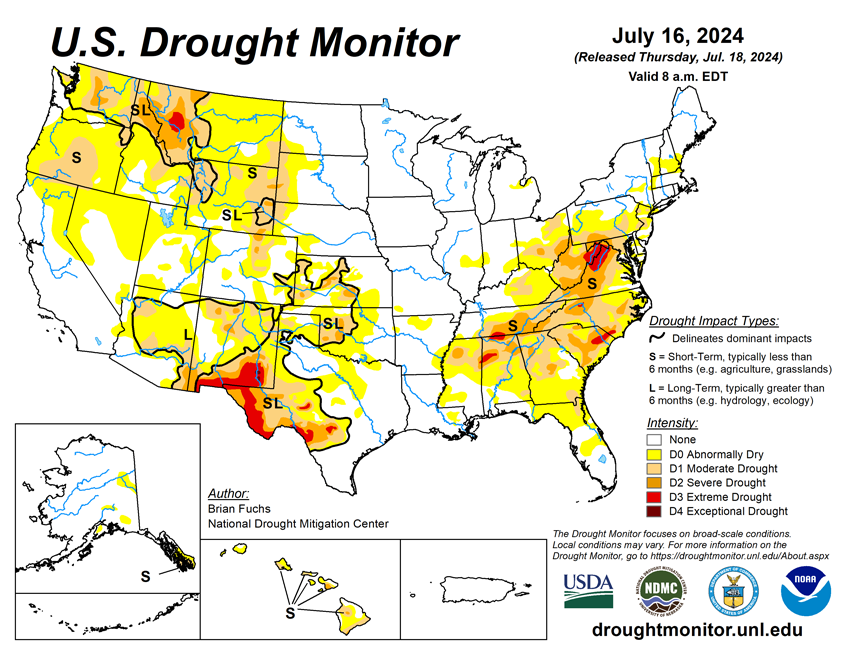
As of July 16, 2024, 17.41% of the U.S. and Puerto Rico and 20.55% of the lower 48 states are in drought, according to the U.S. Drought Monitor.
This Week's Drought Summary…
Over the past week, remnants of Beryl made their way up into the Midwest, bringing with them significant precipitation from east Texas all the way into Michigan. Another shot of significant rain at the end of the current period in the Midwest kept the region quite wet overall. Significant precipitation along the eastern seaboard from New Jersey into the Carolinas was welcomed, but isolated to coastal areas. Much of the rest of the country was quite dry with only pockets of light precipitation. The warmest temperatures were over the West, with departures of 3-6 degrees above normal widespread, and from Washington to California, with departures 9-12 degrees above normal. The coolest temperatures were also associated with areas that picked up the best rains as temperatures from Texas into Arkansas and Missouri were up to 3 degrees below normal. Areas of the Northeast were also warmer than normal with departures of 6-9 degrees above normal.

Looking Ahead...
Over the next 5-7 days, an active pattern appears to be developing from the Southwest, Plains, and into the Southeast and eastern seaboard. The most significant precipitation is anticipated over New Mexico, southern Colorado, northeast Texas, and from Louisiana through Virginia. Dry conditions are anticipated over much of the West and Midwest during this period. Cooler-than-normal temperatures are anticipated over much of the Plains, South and into the Southeast, with some departures from normal approaching 9-11 degrees below normal in portions of Nebraska, Kansas and into Colorado and New Mexico. Warmer-than-normal temperatures will dominate the West with departures of 11-13 degrees above normal over the Great Basin and into the northern Rocky Mountains. Near-normal temperatures are anticipated over other areas.
The 6-10 day outlooks show that the greatest chances of below-normal temperatures will be over the southern Plains into portions of the South, Southwest and southern Midwest. The greatest probability of experiencing above-normal temperatures during this time will be over the West and the Florida peninsula and portions of the Northeast. The highest probability of above-normal precipitation will be over Texas with the area from the Southwest into the Mid-Atlantic also expected to have above-normal chances of above-normal precipitation. The area with the greatest chances of below-normal precipitation will be over the northern Rocky Mountains into the northern High Plains.