
National Current Conditions: 9/11/24 thru 9/17/24
Every state in the Midwest saw degradations for the second week in a row. Meanwhile, Hurricane Francine brought heavy rainfall—and drought improvements—in the South/Southeast.
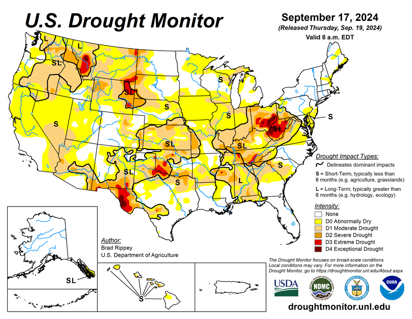
As of September 17, 2024, 29.76% of the U.S. and Puerto Rico and 35.59% of the lower 48 states are in drought, according to the U.S. Drought Monitor.
This Week's Drought Summary…
On September 11, Francine became the third and strongest hurricane of the season to strike the U.S. Gulf Coast, following Beryl (in Texas) in early July and Debby (in Florida) in early August. Francine briefly achieved sustained winds near 100 mph while making landfall around 5 pm CDT in Louisiana’s Terrebonne Parish. Hurricane-force wind gusts (74 mph or higher) spread as far inland as New Orleans, where a gust to 78 mph was clocked at Louis Armstrong International Airport. Meanwhile in the Mississippi Delta, antecedent dryness minimized flooding, although rainfall topped 4 inches in many locations and localized wind gusts briefly topped 50 mph. As the former hurricane drifted farther inland, days of locally heavy showers led to pockets of flash flooding, extending as far east as Alabama and the Florida Panhandle. Less than a week later, on September 16, Potential Tropical Storm Eight moved ashore in northeastern South Carolina and delivered flooding rainfall (locally a foot or more) across southeastern North Carolina. By the morning of September 17, the end of this drought-monitoring period, much of North Carolina and portions of neighboring states had received significant rain. The remainder of the country largely experienced dry weather, leaving widespread soil moisture shortages across the Plains and Midwest—a classic late-summer and early-autumn flash drought. In the western U.S., a cooling trend was accompanied some rain and high-elevation snow, heaviest across the northern Rockies and environs. As the long-running Western heat wave subsided, late-season warmth replaced previously cool conditions across the Plains, Midwest, and Northeast. Nationally, nearly one-half (46%) of the rangeland and pastures were rated in very poor to poor condition on September 15, according to the U.S. Department of Agriculture, up from an early-summer minimum of 19%.

Looking Ahead...
During the next 5 days, active weather across the nation’s mid-section could lead to significant precipitation in from the central sections of the Rockies and Plains into the upper Midwest. While rain could slow agricultural fieldwork, including harvest activities, rangeland, pastures, and recently planted winter wheat will benefit from a boost in topsoil moisture. In contrast, generally dry weather will prevail across the remainder of the country, excluding the Atlantic Coast States. However, the western Caribbean Sea will need to be monitored for tropical cyclone development, with possible future implications for the eastern U.S.
The NWS 6- to 10-day outlook for September 24-28 calls for of near- or above-normal temperatures nationwide, with the West, North, and southern Texas having the greatest likelihood of experiencing warmer-than-normal weather. Meanwhile, near- or below-normal precipitation across the western and north-central U.S., as well as northern New England, should contrast with wetter-than-normal conditions from the central and southern Plains to the Atlantic Coast, extending as far north as the Ohio Valley and southern New England.


