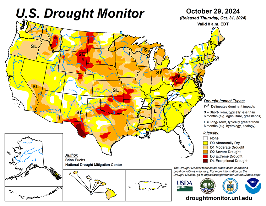
National Current Conditions: October 23, 2024 - October 29, 2024
The U.S. saw a huge expansion of drought for the fourth week in a row. Conditions worsened in every state from the Plains to the East. Drought is present in every U.S. state except Alaska and Kentucky. This is the greatest number of states in drought in U.S. Drought Monitor history.
As of October 29, 2024, 45.27% of the U.S. and Puerto Rico and 54.08% of the lower 48 states are in drought, according to the U.S. Drought Monitor.
This Week's Drought Summary…
The dry pattern that has been impacting much of the country has continued into this current period. The wettest areas were along the coast in the Pacific Northwest, with some locations recording over 2 inches of rain for the week. Other areas receiving some precipitation were in the Four Corners region, the Midwest and parts of the South, but many of these totals were minimal and did little to impact the drought conditions. The Southern Plains and South were the warmest regions, with departures of 10-12 degrees above normal this week. Almost the entire country was warmer than normal, with only areas of the Northeast and Pacific Northwest having near to slightly below normal temperatures. As the month is ending, many locations will be at or near record dryness across the country. For the Lower 48 states, there has not been this much drought shown on the U.S. Drought Monitor since December 2022. Areas of the Southeast that were impacted by significant precipitation associated with landfalling hurricanes have dried out rapidly, with some locations recording zero precipitation since the hurricanes. Some precipitation development at the end of the current period could help ease conditions into the next week, but that will be determined on the next map.

Looking Ahead...
Over the next 5-7 days, it is anticipated that the dry pattern will break over much of the Plains, Midwest and into the South, with widespread precipitation from north Texas to Wisconsin. The Western portions of the country will also be in a more active pattern, with the coastal areas, the Great Basin, and part of the Rocky Mountains seeing some precipitation. Temperatures will continue to be warmer than normal out in front of the precipitation, with the eastern Midwest, South, and East all anticipated to be warmer than normal, including departures of 13-15 degrees above normal in the Ohio River basin. Cooler- than-normal temperatures will settle in over the West, with departures of 10-13 degrees below normal over much of Nevada.
The 6-10 day outlooks show that the best chance for above-normal temperatures is over the East while much of the West has the best chance for below-normal temperatures centered on the Southwest. The greatest chance for above-normal precipitation is over the southern Rocky Mountains with above normal chances in the Plains and into the Midwest while the greatest chance for below-normal precipitation is over northern California and much of the West.


