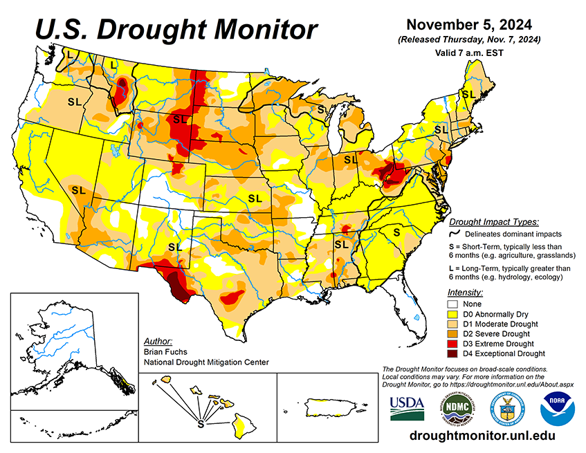
National Current Conditions: October 30, 2024 - November 5, 2024
A large swath of the Central U.S. saw good precipitation this past week, improving drought in the Southern Plains, South, and western Midwest.
However, conditions in the East worsened, especially in the Northeast/Mid-Atlantic. As of November 5, 2024, 43.4% of the U.S. and Puerto Rico and 51.89% of the lower 48 states are in drought, according to the U.S. Drought Monitor.
This Week's Drought Summary…
Over the last week, weather systems tracked over the southern Plains and into the Midwest, bringing much-needed precipitation. Some areas of Arkansas and Missouri reported over 10 inches of rain for the week. The active pattern also continued over the Pacific Northwest, with the coastal areas and inland recording 2-4 inches of rain that helped to alleviate dryness. Temperatures over the West were below-normal for the week, by as much as 6-9 degrees in parts of Nevada, Utah and Arizona. The rest of the country had warmer-than-normal temperatures, especially in Texas and into Louisiana, Mississippi, Arkansas and Alabama, where they were 9-12 degrees above normal. Many areas that received rain during the period had these rains come on the cusp of record-setting dryness in October, but many records were still set for areas that didn’t receive rain at the end of October and early November.

Looking Ahead...
Over the next 5-7 days, it is anticipated that the wet pattern will continue over much of the southern Plains and into the South, Southeast, and Midwest. The active pattern along the coastal areas of the Pacific Northwest will also continue. Greatest precipitation is anticipated over the southern Plains, western Tennessee, western Kentucky, northern Mississippi, southern Georgia, western South Carolina and the Pacific Northwest coast, where 3 or more inches of rain is anticipated. Much of the West will remain dry. Temperatures will remain cooler than normal over much of the West with departures of 10-12 degrees below normal over northern New Mexico and southern Colorado. Much of the eastern half of the country will be warmer than normal, while areas of the Midwest and South are anticipated to be 10-12 degrees below normal for the week. Hurricane Rafael has formed in the Gulf of Mexico and is projected to track westward. It may not make landfall until the middle of next week but could impact the dryness over the South and southern Plains depending on its path.
The 6-10 day outlooks show that the probability of above-normal temperatures will be greatest over the eastern half of the United States, especially over the Midwest and into the Southeast. Chances of cooler-than-normal temperatures are greatest over the West, in particular over California and Nevada. Most of the country has a good chance of recording above-normal precipitation during the period, especially over the Pacific Northwest.


