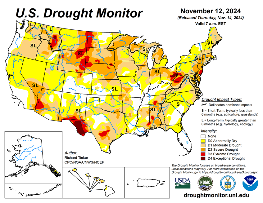
National Current Conditions: November 6, 2024 - November 12, 2024
More November rain (and some snow) led to more drought improvement in the Central U.S., especially in the Plains, South, and Midwest. However, much of the Eastern U.S. worsened for the second week in a row.
As of November 12, 2024, 41.67% of the U.S. and Puerto Rico and 49.84% of the lower 48 states are in drought, according to the U.S. Drought Monitor.
This Week's Drought Summary…
Storm systems brought significant precipitation and drought relief to broad areas in the central Rockies, central and southern Plains, Lower and Middle Mississippi Valley, Lower and Middle Ohio Valley, and the South Atlantic Region. Meanwhile, subnormal precipitation and some unseasonable warmth led to deterioration in dryness and drought conditions in portions of the Southwest, southern and western Texas, the interior Southeast, the northeastern Gulf Coast, the central and southern Appalachians, the mid-Atlantic region, the Northeast. Excessive precipitation totals fell on some areas. From central South Carolina through much of southeastern Georgia, amounts of 4 inches to locally a foot of rain were reported. Similar totals fell on central Louisiana, a band through central and north-central Texas, small parts of the Lower Ohio Valley, and orographically-favored areas in the Northwest. In addition, a broad area covering the eastern half of Colorado and adjacent areas in New Mexico and the central High Plains recorded 2 to 4 inches of precipitation, much of which fell as snow in the middle and higher elevations. A few scattered sites reported 3 to 4.5 feet of snow, mainly in the higher elevations of Colorado.

Looking Ahead...
During the next five days (November 14-18), moderate to heavy precipitation is again expected from the Cascades westward to the Pacific Coast, with totals expected to exceed 5 inches expected in some of the higher elevations and orographically-favored sites. One or more inches are also anticipated in the Sierra Nevada, with several tenths of an inch possible along most of the California Coast down to the Mexican border. Parts of the northern Intermountain West are expected to receive over an inch of precipitation, with 2 to locally 4 inches forecast across the Idaho Panhandle. A low pressure system and trailing front should trigger another round of heavy precipitation in the central and southern Great Plains from central Texas northward into southeastern Nebraska and the Middle Mississippi Valley, with 1.5 to locally 4.0 inches anticipated from central and east-central Kansas southward through the Red River (south) Valley and adjacent northern Texas. At least an inch is also anticipated east of the Lower and Middle Mississippi River through the interior Southeast, Lower Ohio Valley, central and southern Appalachians, and the mid-Atlantic region. Over 2 inches may fall on parts of the central Appalachians and adjacent Piedmont. Meanwhile, moderate amounts should fall on the southern Rockies and adjacent High Plains and across the Great Lakes region and the northern Ohio Valley. In contrast, little or no precipitation is expected across much of the Northeast, Florida and the adjacent South Atlantic region, southern Texas, the northern Plains, the central and southern Rockies, and the Southwest.
The 6-10 day outlook (valid November 19-23) features enhanced chances for both above-normal precipitation and temperatures across the Upper Midwest and across most areas east of the Mississippi River, with odds for significantly above-normal rainfall reaching 50 to near 70 percent on the Florida Peninsula. Wetter than normal weather is also slightly favored across Hawaii. Meanwhile, subnormal precipitation seems more likely across Texas and adjacent locations as well as the western Rockies, most of the Intermountain West, and the Sierra Nevada. Below normal temperatures are favored across the central and southern Plains and adjacent Mississippi Valley, the Rockies, and the Intermountain West. Southeastern Alaska should also average colder than normal while in Hawaii, neither extreme of temperature is favored.


