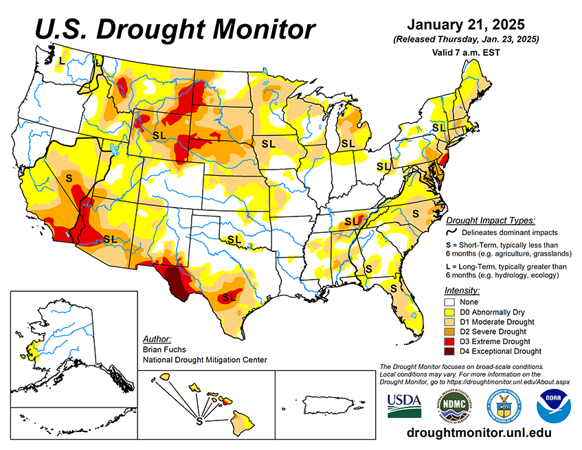

National Current Conditions: January 15, 2025 - January 21, 2025
Drought worsened again in central Texas, the Southwest, and Southern California. Drought expanded in central California too. Pockets of the Northwest, Rockies, and Midwest saw improvements, with mixed degradations and improvements in the Southeast.
As of January 21, 2025, 31.50% of the U.S. and Puerto Rico and 37.56% of the lower 48 states are in drought, according to the U.S. Drought Monitor.
This Week's Drought Summary…
Almost all the U.S. experienced a cooler-than-normal week, with only a handful of areas being above normal. The coolest readings were in the Rocky Mountains, where departures were up to 15 degrees below normal, while the warmest areas were in central and northern California, New England, and south Florida, where departures were a few degrees above normal. Precipitation was also greatest in the Rocky Mountains where the upper elevations recorded a good week of snow. Precipitation was widely scattered throughout the Southeast where some portions of north Florida had over 200% of normal precipitation for the week. At the end of the period, a cold air mass settled in over the eastern two-thirds of the country, bringing cold air all the way down into the deep South with winter storms along the Gulf Coast. There are multiple regions that have had several weeks of dryness with minimal precipitation. Even though it is winter, and drought tends to move slower due to reduction of demand, these areas will continue to be monitored for degradation if the pattern continues and the data support it.
Looking Ahead...
Over the next five to seven days, it is anticipated that the greatest precipitation will be over the South into the Southeast from east Texas into western Alabama. Much of the country will see little to no precipitation with the most active precipitation areas from California into Wyoming and Montana, but amounts will generally be less than 1 inch for most locations. Temperatures are anticipated to be warmest over the central Plains to the upper Midwest with departures of 5-10 degrees above normal. The coolest temperatures will be in the west with most areas 5-10 degrees below normal.
The 6-10 day outlooks show that the probability of below-normal temperatures is greatest over the Southwest and in New England, while the greatest chances of above normal temperatures are over the High Plains and upper Midwest. Above-normal chances of above-normal precipitation are greatest over the southern United States from New Mexico into the Mid-Atlantic. The best chances of below normal precipitation are over the West and High Plains into the Midwest.


