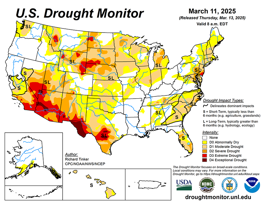
Last week brought substantial precipitation (over 1.5 inches) to parts of western Washington, the central and southern Sierra Nevada, southwestern California, portions of the western Mississippi Valley from southern Minnesota into Louisiana and eastern Texas, a swath across the Gulf Coast and South Atlantic States, and the eastern tiers of the mid-Atlantic and Northeast. The highest totals (3 to locally 8 inches) were recorded across northern Florida and adjacent Georgia, and northwesternmost Washington. More than 3 inches also fell on scattered small patches of the Sierra Nevada, in a swath from central Mississippi through western Georgia, and central South Carolina. In contrast, only a few tenths of an inch of precipitation barely dampened most of the Ohio Valley and adjacent Appalachians, and from the central and western Plains to the Pacific Coast, although some of the higher elevations of the central Rockies recorded moderate amounts. Central and southern portions of the Florida Peninsula also recorded a few tenths of an inch at best. Meanwhile, it was an abnormally warm week across the entire northern tier of the country outside far western Washington, from the central Plains eastward through the mid-Atlantic, and across central and southern Texas. Daily maximum temperatures averaged 12 to 15 deg. F above normal for the 7-day period over the central and northern Dakotas and adjacent Minnesota. Somewhat below-normal temperatures were observed from the central Rockies westward to the Pacific Coast and southward to the Mexican Border.
Looking Ahead...
The March 13-17 period starts out unusually mild in a large part of the central and eastern U.S. while relatively cool weather stretches from the Rockies to the Pacific Coast. On March 13, temperatures may reach the upper 70’s deg. F as far north as central South Dakota, central Indiana, West Virginia, and North Carolina. Portions of central and southern Texas are expected to top 90 deg. F. It’ll be a little cooler in the mid-Atlantic and Northeast, with highs in the low 60’s deg. F at best, and probably not above 45 deg. F in most of New England. As the period progresses, warm air pushes south and east toward the Atlantic Ocean while a shot of cold air invades the northern Plains. Lows are expected to drop into the teens in parts of the northern Plains that are expected to top 75 deg. F just two days earlier. The cold intrusion looks to be short-lived, with the air mass moderating as it pushes east. On March 17, warmer weather is expected to again build into the Plains. Meanwhile, the western half of the CONUS remains relatively cool. Much of the Sierra Nevada, Cascades, Pacific Northwest Coast, and northern California are anticipating more than 4 inches of precipitation for the 5-day period, with 5 to locally 8 inches possible in northwestern California and adjacent Oregon. Elsewhere from the Rockies westward, fairly widespread light to moderate precipitation is forecast, with heavier totals of 1.5 to locally 4.0 inches falling on some of the higher elevations (particularly in central and northern Idaho) and parts of the central and southern California Coastline. Most lower elevations should expect lesser amounts of several tenths to an inch. Farther east, a swath of heavy rain is anticipated from the lower Ohio Valley southward into portions of the Gulf Coast States. More than 1.5 inches is forecast there, with amounts exceeding 3 inches possible in northeastern Mississippi, northern Alabama, and central Tennessee. Moderate amounts of at least 0.5 inch should fall elsewhere from the Mississippi River to the Atlantic Seaboard, with lesser totals expected over most of Maine, southern Florida, and the western Great Lakes. In the middle of the country, at least a few tenths of an inch of precipitation are forecast for the east-central and northeastern Great Plains and the Upper Mississippi Valley, with amounts approaching of slightly exceeding an inch over most of Minnesota and adjacent portions of South Dakota and Iowa. Dry weather is anticipated across the High Plains and the southern half of the Great Plains, with a few tenths of an inch falling at best.
The Climate Prediction Center’s 6-10 day outlook valid March 18-22, 2025 favors a continuation of below-normal temperatures from the Rockies westward, and warmer than normal weather over most of the central and eastern states. Odds for unusual warmth top 60 percent from the Ohio Valley and mid-Atlantic northward to the Canadian border while there is over a 70 percent chance of unusually cool conditions in the western Great Basin. Hawaii has significantly enhanced odds for above-normal temperatures (over 60 percent), and the dry areas of southern Alaska should also average warmer than normal, although with lower probabilities. Meanwhile, subnormal precipitation continues to be favored across most of Texas and Oklahoma, and there are slightly enhanced chances for drier than normal weather over part of North Dakota and along the South Atlantic Seaboard. The rest of the country should average near- or wetter-than-normal, with the best odds for surplus precipitation over and near the Pacific Northwest. Above-normal precipitation is also favored for the western half of Hawaii and for the dry areas in Alaska.