National Current Conditions... April 2nd thru April 8th, 2025

A stormy week led to drought improvements in the Midwest, South, East, and parts of the Plains. But for the 13th week in a row, drought expanded in the Southwest, and outlooks favor warmer and drier than normal conditions.
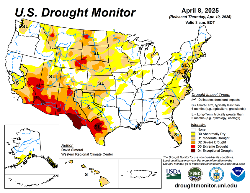
As of April 8, 2025, 32.29% of the U.S. and Puerto Rico and 38.47% of the lower 48 states are in drought, according to the U.S. Drought Monitor.

This Week's Drought Summary…
This U.S. Drought Monitor (USDM) week saw widespread improvement in drought-related conditions across areas of the South, Southeast, and Midwest, where a series of strong storms delivered heavy rainfall, damaging winds, and severe flooding. The multi-day storm event saturated soils leading to inundation of rivers, and severe flooding in low-lying areas from Arkansas to Ohio. Storm totals from the multi-day event ranged from 4 to 18+ inches, with the highest accumulations observed across central Arkansas, southeastern Missouri, and western portions of both Tennessee and Kentucky. In addition to heavy rainfall, the storm system sparked dozens of tornadoes as well as strong gusty winds in other areas, causing widespread power outages. Elsewhere, improving conditions over the past 30 to 60 days, led to reduction in areas of drought in the Northeast, from New York to Maine, as well as in areas further south including New Jersey and Virginia. In the Midwest, this week’s rainfall event pushed rainfall totals well above normal levels for the past 30-day period, leading to improvements across the Midwest in Missouri, Illinois, Indiana, and Michigan.
In the Upper Midwest and portions of the Plains, drought-related conditions improved on the map across areas of Minnesota, Wisconsin, and South Dakota, where precipitation has been above normal for the past 30-90-day period and soil moisture monitoring products are showing normal to above-normal levels. In the West, above-normal springtime temperatures are causing a rapid melting of high-elevation snowpacks across the entire region. Looking at the current snowpack conditions out West, deep seasonal snowpack deficits remain across the ranges of southwestern Colorado, New Mexico, northern Arizona, and southwestern Utah. Elsewhere in the region, areas of the Great Basin and Intermountain West saw improvements on the map including parts of northeastern Nevada, Wyoming, and northwestern Colorado. In terms of reservoir storage in the West, California’s reservoirs continue to be at or above historical averages for the date (April 8), with the state’s two largest reservoirs, Lake Shasta and Lake Oroville, at 116% and 120% of average, respectively. In the Southwest, the U.S. Bureau of Reclamation is reporting (April 6) Lake Powell at 33% full, Lake Mead at 34% full, and the total Colorado system at 41% full (compared to 42% full at the same time last year).