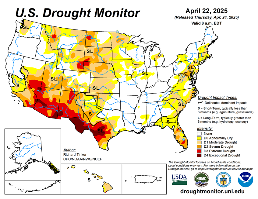
During April 23-28, 2025, substantial portions of the contiguous United States are expecting at least moderate precipitation (several tenths), with scattered heavy amounts over 2 inches. This includes a swath from northwestern Wyoming across southern Montana and most of the Dakotas, the Upper Mississippi Valley, through much of the Great Lakes and New England. Heavy amounts could be most widespread in the Red River (south) Valley, central Oklahoma, and from the central Plains into Iowa. In addition, most of the central and southern Great Plains should receive several tenths of an inch to near 2 inches, along with the Lower Mississippi Valley, southern and central Appalachians, and the interior Southeast. Elsewhere, several tenths of an inch are expected in the Middle Mississippi Valley, the lower Great Lakes, and from the South Atlantic States into southern New England. In the West, a few tenths to about 1.5 inches of precipitation are forecast for southern Oregon, northern and eastern California, the northern Great Basin, and the swath of higher elevations from central Utah through western Montana and adjacent Idaho. Meanwhile, little or no precipitation is forecast for most of the Four Corners Region, southern sections of the Great Basin and California, southern Texas, the immediate Gulf Coast, most of Florida, and southeastern Georgia. Temperatures are expected to average below normal in the Southwest and California, but above normal over most other portions of the contiguous United States. Daily high temperatures are expected to average 8 to 10 deg. F. above normal over the Northeast and mid-Atlantic Region, parts of the Lower Mississippi Valley and adjacent areas, and many locations in and around South Dakota.
The 6-10 day outlook valid April 29 – May 3, 2025 favors wetter than normal conditions southeastern Rockies eastward through the Middle and Lower Mississippi Valley, and most of the Eastern States outside eastern New England and southern Florida. Meanwhile, subnormal precipitation is most likely across the northern Plains, central and western Rockies, the Intermountain West, and California. Wet weather is slightly favored in the remaining dry areas in southeastern Alaska and Hawaii. Warm weather should prevail across the contiguous United States outside the southern High Plains and adjacent Rockies. The greatest odds for warmth extend from California and the Great Basin through the northern Rockies and Intermountain West, plus across the lower Mississippi Valley and the Eastern States. Warmth is also significantly favored across Hawaii. Subnormal temperatures are expected to be limited to Alaska.